Category:Railroad maps of Philadelphia
Jump to navigation
Jump to search
Maps of railroads in and near Philadelphia, Pennsylvania.
Media in category "Railroad maps of Philadelphia"
The following 11 files are in this category, out of 11 total.
-
 1849 map of proposed railroad line through West Philadelphia.jpg 7,152 × 5,648; 2.62 MB
-
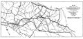 1920 Philadelphia and Columbia.jpg 2,000 × 956; 595 KB
-
 1948 original railroads in Philadelphia.jpg 5,374 × 3,285; 1.1 MB
-
 30thStreet-Strecken02.png 1,603 × 1,242; 615 KB
-
 30thStreetStation-highline-de.png 1,603 × 1,242; 623 KB
-
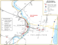
 30thStreetStation-highline-en.png 1,603 × 1,242; 629 KB
-
 30thStreetStation-overview-de.png 1,603 × 1,242; 618 KB
-
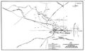
 30thStreetStation-overview-en.png 1,603 × 1,242; 624 KB
-
 30thStreetStation-overview-en.svg 1,601 × 1,241; 170 KB
-
 Phila - RR - 1857-58.jpg 5,280 × 6,128; 4.78 MB
-
 West Philly.svg 1,824 × 2,544; 13 KB


