Category:Rail transport maps of Oise
Jump to navigation
Jump to search
Media in category "Rail transport maps of Oise"
The following 5 files are in this category, out of 5 total.
-
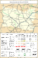 Railway map of France - 60 - 1900 - fr - small.svg 564 × 861; 6.77 MB
-
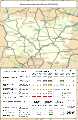 Railway map of France - 60 - 1930 - fr - small.svg 564 × 861; 9.59 MB
-
 Railway map of France - 60 - 1950 - fr - small.svg 564 × 861; 7 MB
-
 Railway map of France - 60 - 1980 - fr - small.svg 564 × 861; 7.11 MB
-
 Railway map of France - 60 - 2020 - fr - small.svg 564 × 861; 6.97 MB


