Category:Rail transport maps of Loire-Atlantique
Jump to navigation
Jump to search
Media in category "Rail transport maps of Loire-Atlantique"
The following 8 files are in this category, out of 8 total.
-
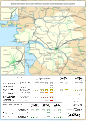
 Railway map of France - 44 - 1880 - fr - small.svg 705 × 985; 8.44 MB
-
 Railway map of France - 44 - 1900 - fr - small.svg 705 × 985; 8.56 MB
-
 Railway map of France - 44 - 1913 - fr - small.svg 705 × 985; 8.71 MB
-
 Railway map of France - 44 - 1932 - fr - small.svg 705 × 985; 8.77 MB
-
 Railway map of France - 44 - 1950 - fr - small.svg 705 × 985; 8.66 MB
-
 Railway map of France - 44 - 1980 - fr - small.svg 705 × 985; 8.66 MB
-
 Railway map of France - 44 - 2000 - fr - small.svg 705 × 985; 8.68 MB
-
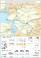
 Railway map of France - 44 - 2020 - fr - small.svg 705 × 985; 8.52 MB


