Category:Radfall
Jump to navigation
Jump to search
village in Kent, United Kingdom  | |||||
| Upload media | |||||
| Instance of | |||||
|---|---|---|---|---|---|
| Location | Chestfield, Canterbury, Kent, South East England, England | ||||
 | |||||
Media in category "Radfall"
The following 27 files are in this category, out of 27 total.
-

-
 Access track in Clowes Wood geograph-1826271-by-David-Anstiss.jpg 3,072 × 2,304; 1.54 MB
-
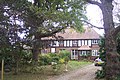 Bluebell Cottage, Radfall - geograph.org.uk - 1524095.jpg 640 × 427; 114 KB
-
 Bridleway to Radfall Road 1826325 f16b32b6.jpg 3,072 × 2,304; 3.02 MB
-
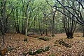
 Coppiced trees Clowes Wood geograph-2751479-by-N-Chadwick.jpg 640 × 430; 139 KB
-
 Derelict Cottage, Radfall - geograph.org.uk - 1524098.jpg 640 × 427; 71 KB
-
 Disused link road near Radfall Road 1827164 f8a79c53.jpg 3,072 × 2,304; 2.04 MB
-
 Exit from Clowed Wood onto Radfall Road 5809257 940daa9b.jpg 4,000 × 3,000; 4.63 MB
-

-
 Gypsy Corner on Radfall Road - geograph.org.uk - 480533.jpg 640 × 480; 71 KB
-

-

-
 Old route of Radfall Road 4060005 90267908.jpg 3,488 × 2,616; 3.59 MB
-
 Path in Clowes Wood geograph-2751475-by-N-Chadwick.jpg 640 × 430; 140 KB
-
 Radfall Ride 1827145 b1ec3e98.jpg 3,072 × 2,304; 2.66 MB
-
 Radfall Ride Radfall 4059999 309dd816.jpg 3,488 × 2,616; 3.17 MB
-
 Radfall Ride.jpg 1,600 × 1,030; 351 KB
-
 Radfall Road - geograph.org.uk - 413329.jpg 640 × 480; 142 KB
-
 Radfall Road at Gypsy Corner 5809254 492c203b.jpg 4,000 × 3,000; 4.65 MB
-
 Radfall Road heading south 5828977 dee21128.jpg 1,024 × 684; 434 KB
-
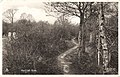
 Radfall Road in Thornden Wood - geograph.org.uk - 1524092.jpg 640 × 427; 53 KB
-
 Radfall Road near Radfall 4059971 eba22d69.jpg 3,488 × 2,616; 2.18 MB
-
 Radfall Road near Radfall 4059974 352da1a8.jpg 3,488 × 2,616; 2.19 MB
-
 Radfall Road near Radfall geograph-4059986-by-Chris-Whippet.jpg 3,488 × 2,616; 3.02 MB
-
 Spot the Bridleway geograph-2751477-by-N-Chadwick.jpg 640 × 430; 148 KB
-
 Two Ants nests in Clowes Wood - geograph.org.uk - 1520906.jpg 640 × 427; 122 KB
-


