Category:Raadhuis, Oud-Beijerland
Jump to navigation
Jump to search
| Object location | | View all coordinates using: OpenStreetMap |
|---|
 | |||||
| Upload media | |||||
| Instance of | |||||
|---|---|---|---|---|---|
| Location | Oud-Beijerland, Hoeksche Waard, South Holland, Netherlands | ||||
| Street address |
| ||||
| Located on street |
| ||||
| Heritage designation |
| ||||
 | |||||
|
This is a category about rijksmonument number 31919
|
| Address |
|
Media in category "Raadhuis, Oud-Beijerland"
The following 33 files are in this category, out of 33 total.
-
 Achter- en linker zijgevel - Oud-Beijerland - 20178190 - RCE.jpg 1,200 × 1,001; 223 KB
-
 Achtergevel - Oud-Beijerland - 20178182 - RCE.jpg 891 × 1,200; 210 KB
-
 Achtergevel - Oud-Beijerland - 20178183 - RCE.jpg 861 × 1,200; 194 KB
-
 Burgermeesterskamer - Oud-Beijerland - 20178194 - RCE.jpg 1,200 × 950; 160 KB
-
 Burgermeesterskamer - Oud-Beijerland - 20178195 - RCE.jpg 1,200 × 942; 165 KB
-
 Deel voorgevel gezien van rechts - Oud-Beijerland - 20327101 - RCE.jpg 896 × 1,200; 191 KB
-
 Gevels - Oud-Beijerland - 20178180 - RCE.jpg 889 × 1,200; 207 KB
-
 Gevels - Oud-Beijerland - 20178181 - RCE.jpg 880 × 1,200; 205 KB
-
 Interieur - Oud-Beijerland - 20178198 - RCE.jpg 1,200 × 958; 132 KB
-
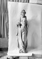 Justitiabeeld voor en na de restauratie - Oud-Beijerland - 20178184 - RCE.jpg 872 × 1,200; 123 KB
-
 Justitiabeeld voor en na de restauratie - Oud-Beijerland - 20178185 - RCE.jpg 890 × 1,200; 126 KB
-
 Justitiabeeld voor en na de restauratie - Oud-Beijerland - 20178186 - RCE.jpg 871 × 1,200; 126 KB
-
 Justitiabeeld voor en na de restauratie - Oud-Beijerland - 20178187 - RCE.jpg 890 × 1,200; 117 KB
-
 Met Nederlands Hervormde Kerk - Oud-Beijerland - 20178192 - RCE.jpg 1,200 × 965; 173 KB
-
 Omgeving - Oud-Beijerland - 20178196 - RCE.jpg 1,200 × 1,191; 269 KB
-
 Omgeving - Oud-Beijerland - 20178197 - RCE.jpg 1,200 × 1,179; 259 KB
-
 Overzicht achtergevel - Oud-Beijerland - 20377395 - RCE.jpg 926 × 1,200; 237 KB
-
 Overzicht met Raadhuis - Oud-Beijerland - 20178289 - RCE.jpg 1,200 × 960; 237 KB
-
 Overzicht voorgevel, bordes met dubbele trap - Oud-Beijerland - 20377393 - RCE.jpg 2,720 × 3,557; 3.47 MB
-
 Raadhuisz.jpg 2,592 × 3,888; 5.91 MB
-
 Raadzaal - Oud-Beijerland - 20178193 - RCE.jpg 1,200 × 936; 174 KB
-
 Rechter zijgevel - Oud-Beijerland - 20178191 - RCE.jpg 1,200 × 958; 236 KB
-
 Schoorsteen - Oud-Beijerland - 20178188 - RCE.jpg 884 × 1,200; 190 KB
-
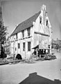
 Voorgevel - Oud-Beijerland - 20178179 - RCE.jpg 859 × 1,200; 237 KB
-
 Voorgevel - Oud-Beijerland - 20178189 - RCE.jpg 1,200 × 958; 198 KB
-
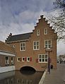
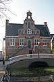
 Voorgevel en brug - Oud-Beijerland - 20326579 - RCE.jpg 1,200 × 871; 228 KB
-
 Voorgevel, aanzicht leeuwtje - Oud-Beijerland - 20371438 - RCE.jpg 783 × 1,200; 259 KB
-

-
 Voorgevel, detail Justitiabeeld - Oud-Beijerland - 20371429 - RCE.jpg 783 × 1,200; 207 KB
-
 Voorgevel, detail Justitiabeeld - Oud-Beijerland - 20371435 - RCE.jpg 783 × 1,200; 203 KB
-
 Voorgevel, detail Justitiabeeld - Oud-Beijerland - 20371436 - RCE.jpg 783 × 1,200; 190 KB
-
 Voorgevel, detail leeuwtje - Oud-Beijerland - 20371439 - RCE.jpg 786 × 1,200; 198 KB
-


