Category:RAF Cowden
Jump to navigation
Jump to search
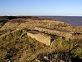
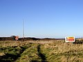
English: RAF Cowden, aerial bombing range, East Riding of Yorkshire, England on the Holderness coast, mostly in the civil parish of Mappleton, also part extends on to northern fringe of civil parish of Aldbrough.
 | |||||
| Upload media | |||||
| Instance of |
| ||||
|---|---|---|---|---|---|
| Location | Cowden, Mappleton, East Riding of Yorkshire, Yorkshire and the Humber, England | ||||
| Operator | |||||
| Inception |
| ||||
| Dissolved, abolished or demolished date |
| ||||
 | |||||
Media in category "RAF Cowden"
The following 7 files are in this category, out of 7 total.
-
 Building Foundations - geograph.org.uk - 326898.jpg 640 × 480; 113 KB
-
 Cowden Cliff - geograph.org.uk - 432819.jpg 487 × 640; 113 KB
-
 Danger Area^ - geograph.org.uk - 326889.jpg 640 × 480; 75 KB
-
 Danger Area^ - geograph.org.uk - 326892.jpg 640 × 480; 92 KB
-
 RAF Cowden 1.jpg 640 × 466; 86 KB
-
 RAF Cowden Air Weapon Range - geograph.org.uk - 432811.jpg 640 × 430; 51 KB
-
 Warning sign, Mappleton - geograph.org.uk - 269710.jpg 640 × 480; 69 KB


