Category:RAF Brüggen
Jump to navigation
Jump to search
former British military Royal Air Force station and airbase near Bruggen in North Rhine-Westphalia, West Germany _Tornado_GR1_ZA600_%27CM%27_of_No._17_Squadron_RAF_from_RAF_Br%C3%BCggen_in_West_Germany,_at_RAF_Wyton_to_celebrate_the_Canberra%27s_40th_anniversary_in_the_Royal_Air_Force,_12_May_1989,_(26996399906).jpg) | |||||
| Upload media | |||||
| Instance of |
| ||||
|---|---|---|---|---|---|
| Part of | |||||
| Location | |||||
| Commissioned by |
| ||||
| Operator | |||||
| Inception |
| ||||
| Date of official opening |
| ||||
| Dissolved, abolished or demolished date |
| ||||
| Significant event | |||||
| Elevation above sea level |
| ||||
| ICAO airport code |
| ||||
 | |||||
Subcategories
This category has only the following subcategory.
Media in category "RAF Brüggen"
The following 14 files are in this category, out of 14 total.
-
 12 Flight RAF Bruggen (3370262396).jpg 1,600 × 1,200; 667 KB
-
 Elmpt, Javelin Barracks - geo.hlipp.de - 4885.jpg 640 × 480; 56 KB
-
 HAS Bruggen.jpg 1,434 × 984; 169 KB
-
 Jaguar GR1 17sq (24192130524).jpg 1,400 × 933; 476 KB
-
 Jaguar GR1 31sq (24820302195).jpg 1,400 × 905; 452 KB
-
 Panavia Tornado GR1, UK - Air Force AN1979418.jpg 1,024 × 683; 238 KB
-
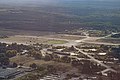
 RAF Brüggen site, Sept 2019 (48810174318).jpg 5,472 × 3,648; 7.92 MB
-
 RAF Brüggen site, Sept 2019 (48810178503).jpg 5,080 × 3,387; 6.5 MB
-
 RAF Brüggen site, Sept 2019 (48810530236).jpg 4,890 × 3,260; 5.27 MB
-
 RAF Brüggen site, Sept 2019 (48810531606).jpg 5,472 × 3,648; 7.88 MB
-

-
 SEPECAT Jaguar GR.1 XZ387 DN 31 Sq Bruggen FINN 30.07.77 edited-3.jpg 1,024 × 697; 860 KB
-
 Tornado GR1 14 Sq (23895413135).jpg 1,400 × 933; 332 KB
-
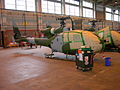 XX386 Gazelle AH.1 12 Flight RAF Bruggen, Germany (3369440265).jpg 1,600 × 1,200; 579 KB
.jpg)


.jpg)
.jpg)

.jpg)
.jpg)
.jpg)
.jpg)

.jpg)
.jpg)