Category:RAF Bassingbourn
Jump to navigation
Jump to search
| Object location | | View all coordinates using: OpenStreetMap |
|---|
former military airbase located in Cambridgeshire  | |||||
| Upload media | |||||
| Instance of |
| ||||
|---|---|---|---|---|---|
| Location | Bassingbourn cum Kneesworth, South Cambridgeshire, Cambridgeshire, East of England, England | ||||
| Operator | |||||
| Inception |
| ||||
| Dissolved, abolished or demolished date |
| ||||
 | |||||
Subcategories
This category has only the following subcategory.
- Aircraft at RAF Bassingbourn (17 F)
Media in category "RAF Bassingbourn"
The following 13 files are in this category, out of 13 total.
-
 B-17-94thbg-bassingborne.jpg 600 × 413; 41 KB
-
 Bassingbourn 1955.jpg 500 × 488; 138 KB
-
 RAF Bassingborn 322d BS 91st BG 1944.jpg 3,712 × 2,994; 1.29 MB
-
 RAF Bassingbourn - 23 Aug 1945 4173.jpg 1,661 × 2,011; 831 KB
-
 RAF Bassingbourn - 26 Jun 1942 623.jpg 1,661 × 1,720; 710 KB
-
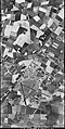
 RAF Bassingbourn - 29 Dec 1943 2.jpg 2,553 × 1,378; 848 KB
-
 RAF Bassingbourn - 29 Dec 1943 3.jpg 2,557 × 1,397; 798 KB
-
 RAF Bassingbourn - 29 Dec 1943.jpg 2,504 × 1,370; 802 KB
-
 RAF Bassingbourn - 31 May 1944.jpg 1,291 × 2,568; 834 KB
-
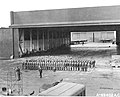
 RAF Bassingbourn - 91st Bombardment Group - Personnel and Buildings 2.jpg 5,431 × 3,564; 4.09 MB
-
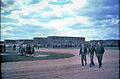
 RAF Bassingbourn - 91st Bombardment Group - Personnel and Buildings.jpg 5,209 × 3,492; 2.94 MB
-
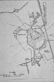 RAF Bassingbourn - Site Map 1.jpg 3,589 × 5,478; 4.85 MB
-
 RAF Bassingbourn - Site Map 2.jpg 3,414 × 3,576; 2.73 MB


