Category:Rüngsdorfer Straße 22
Jump to navigation
Jump to search
| Object location | | View all coordinates using: OpenStreetMap |
|---|
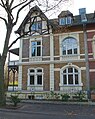
building in Bad Godesberg, Germany | |||||
| Upload media | |||||
| Instance of | |||||
|---|---|---|---|---|---|
| Location | Bad Godesberg, Bonn, Cologne Government Region, North Rhine-Westphalia, Germany | ||||
| Located on street |
| ||||
| Heritage designation | |||||
 | |||||
| This category shows a heritage building in Germany, located in the North Rhine-Westphalian city Bonn (no. A 1910). |
Media in category "Rüngsdorfer Straße 22"
This category contains only the following file.
-
 Bad Godesberg, Rüngsdorfer Straße 22.jpg 3,264 × 4,097; 16.74 MB
