Category:Quin, County Clare
Jump to navigation
Jump to search
Deutsch: Quin ( irisch: Cuinche; dt.: „Fünf Wege“) ist ein Dorf im County Clare im Westen der Republik Irland.
English: Quin (Cuinche, meaning "Five Ways" in Ancient Irish in reference to the original five roads out of the village) is a village in southeast County Clare in Ireland. The village's main attraction, Quin Abbey, is open to the public, and although mostly ruined, much of the structure remains. The abbey was built on the foundations of an earlier Norman castle, and the foundations of its corner towers can still be seen.
Gaeilge: Sraidbhaile in Éirinn is ea Cuinche. Tá an baile suite in iarthar na tíre in oirdheisceart Chontae an Chláir.
village in County Clare, Ireland  | |||||
| Upload media | |||||
| Instance of | |||||
|---|---|---|---|---|---|
| Location | County Clare, Munster, Ireland | ||||
| Elevation above sea level |
| ||||
 | |||||
Subcategories
This category has the following 4 subcategories, out of 4 total.
Media in category "Quin, County Clare"
The following 13 files are in this category, out of 13 total.
-

-

-

-
 Farmland near Quin - geograph.org.uk - 1517958.jpg 640 × 457; 142 KB
-
 Ireland tower house near quin county clare.jpg 192 × 256; 15 KB
-
 Maria Statue in front of Quin Abbey.JPG 1,632 × 1,224; 481 KB
-
 Mine pit of abandoned lead mine Ballyhickey Quin.jpg 5,152 × 3,864; 6.92 MB
-
 Picnic place - geograph.org.uk - 1517959.jpg 640 × 457; 146 KB
-
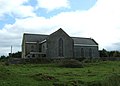 Quin church - geograph.org.uk - 1517965.jpg 640 × 457; 148 KB
-
 Quin old church - geograph.org.uk - 1517980.jpg 457 × 640; 167 KB
-
 The main street in Quin - geograph.org.uk - 1517964.jpg 640 × 457; 141 KB
-
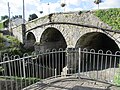 Three arch bridge over the River Rine in Quin.jpg 5,152 × 3,864; 7.01 MB
-
 Three churches at Quin - geograph.org.uk - 1517991.jpg 640 × 457; 143 KB


