Category:Queen's Staith, York
Jump to navigation
Jump to search
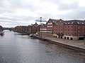
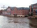
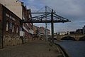
English: The Queen's Staith forms the west bank of the River Ouse to the south of Ouse Bridge. It was built in the C17 and rebuilt early C19.
Subcategories
This category has the following 5 subcategories, out of 5 total.
M
Q
- Queens Staith Road, York (8 F)
V
- Varvil's Warehouse, York (2 F)
W
- Woodsmill Quay, York (25 F)
Y
- York Sea Cadets (6 F)
Media in category "Queen's Staith, York"
The following 13 files are in this category, out of 13 total.
-

-

-
 Queen's Staith - York - geograph.org.uk - 2134821.jpg 640 × 480; 68 KB
-
 Queen's Staith in flood - geograph.org.uk - 1613954.jpg 422 × 640; 54 KB
-
 Queen's Staith York - geograph.org.uk - 1588404.jpg 640 × 480; 97 KB
-
 Queen's Staith, from Ouse Bridge - geograph.org.uk - 1594172.jpg 640 × 480; 51 KB
-
 Queen's Staith, York (1428266667).jpg 2,560 × 1,712; 1.19 MB
-
 Queen's staithe - geograph.org.uk - 2726072.jpg 640 × 480; 74 KB
-
 Queens Staith, York - geograph.org.uk - 6000307.jpg 1,053 × 1,280; 334 KB
-

-
 York -4952 - panoramio.jpg 1,200 × 1,060; 669 KB
-
 York, Queen's Staith - geograph.org.uk - 4057239.jpg 640 × 480; 309 KB
-
 York, Queen's Staith - geograph.org.uk - 5688487.jpg 1,024 × 768; 183 KB


.jpg)


