Category:Qarneh
village in Jarqavieh County, Iran  | |||||
| Upload media | |||||
| Instance of | |||||
|---|---|---|---|---|---|
| Location | Jarqavieh Sofla Rural District, Central District, Jarqavieh County, Isfahan Province, Iran | ||||
| Population |
| ||||
| Elevation above sea level |
| ||||
 | |||||
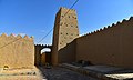
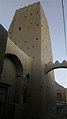
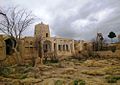
Qarneh is a historical village located 45 km southeast of Isfahan city, located in the wildlife sanctuary of Kolah Ghazi National Park. This village is located in the central part of Jarqouye city. The age of this village is estimated to be about 3500 to 7000 years. There is a cemetery next to this village and on the side of Qarneh mountain. Due to the location of Qarneh mountain in the west of the village, the climate of this village is cooler and more humid than the neighboring villages. The last village of South Braan is the entrance gate of Jarqouye region. Next to the village is Qarne mountain, which is the highest mountain in the region and part of the Kolah Qazi mountain range. Qarne has several famous aqueducts and fertile fields. Its main products are cotton, clover, beet, wheat and barley.
Media in category "Qarneh"
The following 15 files are in this category, out of 15 total.
-
 3572824 روستای قارنه اصفهان.jpg 1,000 × 600; 167 KB
-
 3572832 روستای قارنه اصفهان.jpg 1,000 × 612; 231 KB
-
 3572835 روستای قارنه اصفهان.jpg 1,000 × 602; 246 KB
-
 3572842 روستای قارنه اصفهان.jpg 1,000 × 605; 314 KB
-
 3572843 روستای قارنه اصفهان.jpg 1,000 × 606; 268 KB
-
 3572848 روستای قارنه اصفهان.jpg 1,000 × 608; 319 KB
-
 3572849 روستای قارنه اصفهان.jpg 1,000 × 612; 378 KB
-
 3572851 روستای قارنه اصفهان.jpg 1,000 × 577; 344 KB
-
 3572856 روستای قارنه اصفهان.jpg 1,000 × 608; 255 KB
-
 Anbar ab.jpg 1,024 × 768; 250 KB
-
 Gharneh-borj.jpg 337 × 600; 19 KB
-
 Gharneh-khan.jpg 998 × 705; 126 KB
-
 Gharneh-koche2.jpg 661 × 539; 52 KB
-
 Gharneh-niayeshgah.png 811 × 603; 609 KB
-
 Qarneh.jpg 1,707 × 1,280; 152 KB


