Category:Puitsestraat 2, Leur
Jump to navigation
Jump to search
| Object location | | View all coordinates using: OpenStreetMap |
|---|
_Rijksmonument_9330_Puitsestraat_2.JPG) | |||||
| Upload media | |||||
| Instance of | |||||
|---|---|---|---|---|---|
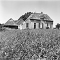
| Location | Leur, Wijchen, Gelderland, Netherlands | ||||
| Street address |
| ||||
| Located on street |
| ||||
| Heritage designation |
| ||||
 | |||||
De Hoek
|
This is a category about rijksmonument number 9330
|
| Address |
|
Media in category "Puitsestraat 2, Leur"
The following 5 files are in this category, out of 5 total.
-
 De Hoek", voor- en linker zijgevel - Leur - 20138896 - RCE.jpg 1,200 × 1,192; 367 KB
-
 Leur (Wijchen) Rijksmonument 9330 Puitsestraat 2.JPG 3,648 × 2,736; 3.85 MB
-
 Voorgevel - Leur - 20138898 - RCE.jpg 1,188 × 1,200; 406 KB
-
 Voorgevel - Leur - 20138899 - RCE.jpg 1,185 × 1,200; 403 KB
-
 Voorgevel met karnmolen - Leur - 20138897 - RCE.jpg 1,188 × 1,200; 424 KB


