Category:Public transport maps of Mannheim
Jump to navigation
Jump to search
Urban districts (cities): Freiburg · Heidelberg · Heilbronn · Karlsruhe · Mannheim · Stuttgart · Ulm
Media in category "Public transport maps of Mannheim"
The following 17 files are in this category, out of 17 total.
-
 Liniennetz MA 2030.jpg 1,629 × 1,500; 1.24 MB
-
 Mannheim, Ludwigshafen and Heidelberg public transport system map (with stations).png 10,732 × 8,478; 39.31 MB
-
 Netzplan Straßenbahn Mannheim und Ludwigshafen.png 2,923 × 2,067; 1.48 MB
-
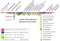
 RheinNeckar S-Bahn Planung 2010.png 1,200 × 600; 29 KB
-
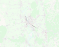
 RNV Geogr Mannheim.JPG 1,800 × 1,440; 1.73 MB
-
 RNV Reginalbild Paradeplatz.JPG 1,920 × 1,200; 1.1 MB
-
 S-Bahn RheinNeckar Netzplan Heidelberg.png 1,000 × 618; 147 KB
-
 S-Bahn RheinNeckar Netzplan Kraichgau.png 1,000 × 693; 183 KB
-
 S-Bahn RheinNeckar Netzplan Kraichgau.svg 1,597 × 1,101; 50 KB
-
 S-Bahn RheinNeckar Netzplan Mannheim.png 1,000 × 663; 153 KB
-
 S-Bahn RheinNeckar Netzplan Neckartal.png 1,000 × 422; 130 KB
-
 S-Bahn RheinNeckar Netzplan Nordbaden.png 1,000 × 445; 150 KB
-
 S-Bahn RheinNeckar Netzplan Pfalz.png 1,000 × 637; 150 KB
-
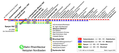
 S-Bahn RheinNeckar Netzplan.png 1,000 × 400; 134 KB
-
 S-Bahn RheinNeckar Netzplan.svg 2,968 × 1,192; 82 KB
-
 Stadt-undStraßenbahnNetzentwicklungMannheim-Ludwigshafen.png 5,475 × 6,358; 2.08 MB
-
 StadtbahnNetzentwicklungWeinheim.png 4,504 × 6,033; 776 KB


.png)