Category:Public transport maps of London
Jump to navigation
Jump to search
Maps and diagrams of the London public transport system
- in this category you will find maps and diagrams not related to railway or London Underground lines
- for maps and diagrams of stations and network closeups, see Category:London Underground maps or Category:Docklands Light Railway maps
- for maps and diagrams of London Underground lines, zones and the entire network, see Category:London Underground lines and subsequent categories
Subcategories
This category has the following 7 subcategories, out of 7 total.
Media in category "Public transport maps of London"
The following 20 files are in this category, out of 20 total.
-

-

-
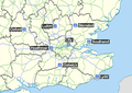 Airports serving london.png 1,208 × 851; 448 KB
-
 Chelsea rail and Tube.png 990 × 970; 1,013 KB
-
 Heathrow Southern Railway.png 1,250 × 1,134; 992 KB
-
 Journal (1913) (14778964824).jpg 3,684 × 2,202; 862 KB
-
 London public transport system map (with stations).png 14,300 × 10,573; 71.17 MB
-
 London public transport system map (without stations).png 7,319 × 5,445; 33.4 MB
-
 London River Services map.svg 1,566 × 566; 49 KB
-
 London Traffic Area Map.png 1,500 × 1,443; 267 KB
-
 London Underground Overground DLR Crossrail map alt.svg 2,500 × 1,340; 214 KB
-
 London Underground Overground DLR Crossrail map zone.pdf 5,208 × 2,750; 120 KB
-
 London Underground Overground DLR Crossrail map zone.svg 2,500 × 1,320; 219 KB
-
 London Underground Overground DLR Crossrail map.pdf 5,208 × 2,750; 90 KB
-
 LPTA map.png 653 × 782; 60 KB
-
 Netzplan S-Bahn London 2019.png 4,579 × 5,540; 2.9 MB
-
 Public Transport Accessibility and Social Mobility.png 4,577 × 4,159; 1.57 MB
-
 SW Chinese Map of the London Underground.svg 5,350 × 3,100; 729 KB
-
 Urban Transport and Morphology - London.png 4,558 × 4,204; 1.01 MB
-
 Woolwich Ferry map.svg 931 × 678; 21 KB
.jpg)


_(14778964824).jpg)


_Edited_by_E._G._Ravenstein_..._Illustrated,_etc%27_(11190630243).jpg)
.png)
.png)