Category:Public transport maps of Denver
Jump to navigation
Jump to search
Media in category "Public transport maps of Denver"
The following 14 files are in this category, out of 14 total.
-
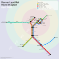 Denver Light Rail Route Diagram.svg 1,720 × 1,720; 1.16 MB
-
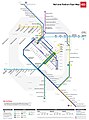
 Denver RTD Rail Map.png 2,472 × 2,032; 673 KB
-
 Denver rtd.svg 5,932 × 4,877; 186 KB
-
 Denverlightrailmap.gif 630 × 780; 48 KB
-
 Denverlightrailmap.svg 1,086 × 789; 75 KB
-
 Denverrail.svg 1,300 × 1,252; 158 KB
-
 Early action bus program - DPLA - 2538e71239d14520eb9a370c65fed7a4.jpg 7,129 × 9,000; 4.31 MB
-
 Electric railway journal (1917) (14575107487).jpg 3,552 × 2,430; 880 KB
-

-

-
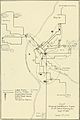
 Present and future Denver light rail lines (as of 2008).jpg 1,024 × 768; 653 KB
-
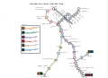
 RTD Denver Rail Map.jpg 1,448 × 1,959; 775 KB
-

-
 The street railway review (1891) (14574068790).jpg 1,338 × 2,006; 220 KB


_(14575107487).jpg)

.jpg)

_(14574068790).jpg)