Category:Public transport maps of Basel
Jump to navigation
Jump to search
Subcategories
This category has the following 6 subcategories, out of 6 total.
Media in category "Public transport maps of Basel"
The following 14 files are in this category, out of 14 total.
-
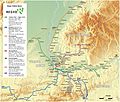 Basel - Regio-S-Bahn Basel - Netzplan (mit Hintergrund).jpg 2,470 × 2,094; 3.77 MB
-
 Basel - Regio-S-Bahn Basel - Netzplan.jpg 2,470 × 2,094; 1.39 MB
-
 Basel Tramwayplan Feral&von Pirch von 1880.png 7,550 × 7,325; 397 KB
-
 Generelles Strassenbahn-Netz Basel von 1913.png 2,538 × 2,722; 3.25 MB
-
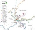
 Liniennetzplan Basel 2024.png 8,971 × 8,168; 27.07 MB
-
 Linienplan trireno 2019 A4h.pdf 1,239 × 1,752; 73 KB
-
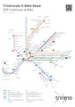
 Linienplan trireno.png 4,638 × 6,448; 944 KB
-
 Nahverkehr in Grenzach-Wyhlen.png 756 × 378; 81 KB
-
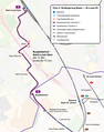
 Tracé Ligne 3 de Distribus.png 652 × 1,824; 80 KB
-
 Tram 3 Saint-Louis.png 1,190 × 1,512; 646 KB
-
 Tram 8 Weil am Rhein.png 1,190 × 1,009; 536 KB
-
 Trambahn-undTrolleybusNetzentwicklungBasel.png 5,344 × 6,273; 1.58 MB
-
 TrambahnGleisplanBasel2018.png 7,125 × 8,334; 2.07 MB
-
 Waldenburgerbahn (BLT).png 1,116 × 475; 25 KB
.jpg)


.png)