Category:Public transport maps of Bangalore
Jump to navigation
Jump to search
Media in category "Public transport maps of Bangalore"
The following 10 files are in this category, out of 10 total.
-
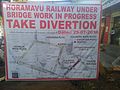 AlternateRoutes Horamavu.jpg 3,264 × 2,448; 1.3 MB
-
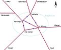 Bangalore city railway schematic.jpg 1,044 × 871; 104 KB
-
 Bangalore Railway Map.png 15,869 × 13,137; 5.49 MB
-
 Bangalore Suburban Rail map 20130928.png 989 × 697; 106 KB
-
 CRS route map - Schematic.jpg 1,152 × 714; 69 KB
-
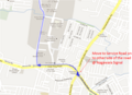 KR Puram to Manyata 1.png 863 × 627; 413 KB
-
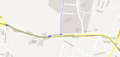 KR Puram to Manyata 2.png 1,090 × 521; 106 KB
-
 NID Bangalore Campus bus route map.png 595 × 842; 34 KB
-
 Phase 2A with WFD line (Apr 2023).jpg 15,890 × 15,361; 6.82 MB
-
 Ramamurthy Nagar Bus route- Schematic diagram.png 1,352 × 796; 172 KB


.jpg)
