Category:Pruchna, Historic former inn
Jump to navigation
Jump to search
| Object location | | View all coordinates using: OpenStreetMap |
|---|
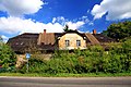
Polski: Dawna gospoda "U Brańczyka" w Pruchnej, XVIII/XIX w.
building in Pruchna, Silesian Voivodeship, Poland  | |||||
| Upload media | |||||
| Instance of | |||||
|---|---|---|---|---|---|
| Location | Pruchna, Gmina Strumień, Cieszyn County, Silesian Voivodeship, Poland | ||||
| Street address |
| ||||
 | |||||
Media in category "Pruchna, Historic former inn"
The following 5 files are in this category, out of 5 total.
-
 Budynek dawnej gospody "U Brańczyka" w Pruchnej 1.JPG 4,524 × 3,016; 11.33 MB
-
 Budynek dawnej gospody "U Brańczyka" w Pruchnej 2.JPG 4,752 × 3,168; 12.49 MB
-
 Budynek dawnej gospody "U Brańczyka" w Pruchnej 3.JPG 3,916 × 2,611; 8.37 MB
-
 POL Pruchna Gospoda u Brańczyka 1.JPG 3,648 × 2,736; 4.19 MB
-
 POL Pruchna Gospoda u Brańczyka 2.JPG 3,200 × 2,400; 2.37 MB


