Category:Protestantse Kerk (Grave)
Jump to navigation
Jump to search
| Object location | | View all coordinates using: OpenStreetMap |
|---|
church building in Grave, Netherlands  | |||||
| Upload media | |||||
| Instance of | |||||
|---|---|---|---|---|---|
| Location | Grave, Land van Cuijk, North Brabant, Netherlands | ||||
| Street address |
| ||||
| Located on street |
| ||||
| Architectural style | |||||
| Heritage designation |
| ||||
| Inception |
| ||||
 | |||||
|
This is a category about rijksmonument number 17209
|
Nederlands: Nederlands Hervormde Kerk, oorspronkelijk kerk van het Begijnhof Maria Graf, vanaf 1581 kerk van het Franciscanessenklooster, later Waalse kerk, thans Ned. Herv. - anno 1526
| Address |
|
Media in category "Protestantse Kerk (Grave)"
The following 42 files are in this category, out of 42 total.
-
 17209 Protestantse kerk 2.jpg 3,320 × 5,184; 8.72 MB
-
 17209 Protestantse kerk.jpg 4,818 × 5,987; 15.23 MB
-

-
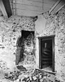
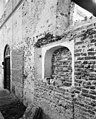
 Deel zuid-gevel interieur - Grave - 20083661 - RCE.jpg 960 × 1,200; 300 KB
-
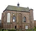
 Exterieur naar het noord-westen - Grave - 20083677 - RCE.jpg 961 × 1,200; 251 KB
-
 Exterieur naar het zuid-oosten - Grave - 20083676 - RCE.jpg 969 × 1,200; 276 KB
-
 Exterieur noord-gevel - Grave - 20083675 - RCE.jpg 962 × 1,200; 230 KB
-
 Exterieur noord-west gevel - Grave - 20083686 - RCE.jpg 965 × 1,200; 234 KB
-
 Exterieur zuid-oost gevel - Grave - 20083685 - RCE.jpg 960 × 1,200; 239 KB
-
 Grave uitzicht kerk protestantse.jpg 2,288 × 1,712; 750 KB
-
 Interieur naar het oosten - Grave - 20083679 - RCE.jpg 946 × 1,200; 177 KB
-
 Interieur naar het oosten - Grave - 20083682 - RCE.jpg 804 × 1,200; 140 KB
-
 Interieur naar het westen - Grave - 20083678 - RCE.jpg 952 × 1,200; 193 KB
-
 Interieur naar het westen - Grave - 20083684 - RCE.jpg 804 × 1,200; 158 KB
-
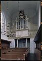 Interieur, aanzicht orgel, orgelnummer 524 - Grave - 20358298 - RCE.jpg 833 × 1,200; 153 KB
-
 Kerk- overzicht Bagijnestraat - Grave - 20083577 - RCE.jpg 1,200 × 959; 269 KB
-
 Noord-gevel ingang exterieur - Grave - 20083659 - RCE.jpg 959 × 1,200; 357 KB
-
 Noord-gevel interieur - Grave - 20083660 - RCE.jpg 958 × 1,200; 323 KB
-
 Noord-gevel interieur midden - Grave - 20083669 - RCE.jpg 958 × 1,200; 288 KB
-
 Noord-gevel links van de ingang - Grave - 20083668 - RCE.jpg 972 × 1,200; 296 KB
-
 Noord-gevel oost-zijde houten raamwerk - Grave - 20083667 - RCE.jpg 961 × 1,200; 309 KB
-
 Noord-gevel tegen west-gevel - Grave - 20083673 - RCE.jpg 958 × 1,200; 292 KB
-
 Noord-gevel, west deel exterieur - Grave - 20083658 - RCE.jpg 959 × 1,200; 359 KB
-
 Noord-oost hoek interieur - Grave - 20083665 - RCE.jpg 958 × 1,200; 284 KB
-
 Plattegrond - Grave - 20083680 - RCE.jpg 844 × 1,200; 285 KB
-
 Plattegrond - Grave - 20083681 - RCE.jpg 461 × 1,200; 142 KB
-
 Plattegrond van de kerk en de poort - Grave - 20083633 - RCE.jpg 1,200 × 892; 183 KB
-
 Preekstoel - Grave - 20083683 - RCE.jpg 805 × 1,200; 181 KB
-
 Protestantse Kerk (Grave) (1).JPG 1,801 × 1,516; 821 KB
-
 Protestantse Kerk (Grave) (2).JPG 2,048 × 1,536; 1.53 MB
-
 Protestantse Kerk (Grave) (3).JPG 1,536 × 2,048; 1.53 MB
-
 Protestantse Kerk (Grave) (4).JPG 2,048 × 1,536; 1.56 MB
-
 Protestantse Kerk (Grave) (5).JPG 1,536 × 2,048; 1.59 MB
-
 West-gevel interieur midden - Grave - 20083672 - RCE.jpg 958 × 1,200; 241 KB
-
 West-gevel interieur noord-zijde - Grave - 20083671 - RCE.jpg 955 × 1,200; 301 KB
-
 Zuid deel west-gevel interieur - Grave - 20083663 - RCE.jpg 976 × 1,200; 284 KB
-
 Zuid-gevel aansluitend tegen west-gevel, interieur - Grave - 20083657 - RCE.jpg 960 × 1,200; 283 KB
-
 Zuid-gevel interieur midden - Grave - 20083662 - RCE.jpg 965 × 1,200; 330 KB
-
 Zuid-gevel midden interieur - Grave - 20083664 - RCE.jpg 960 × 1,200; 320 KB
-
 Zuid-gevel tracering voormalige raam - Grave - 20083674 - RCE.jpg 1,200 × 949; 343 KB
-
 Zuid-gevel west-zijde wandschildering exterieur - Grave - 20083670 - RCE.jpg 961 × 1,200; 323 KB
-
 Zuid-oost hoek interieur - Grave - 20083666 - RCE.jpg 958 × 1,200; 314 KB


_(1).JPG)
_(2).JPG)
_(3).JPG)
_(4).JPG)
_(5).JPG)


