Category:Protestant Church (Laußig)
Jump to navigation
Jump to search
| Object location | | View all coordinates using: OpenStreetMap |
|---|
 | |||||
| Upload media | |||||
| Instance of | |||||
|---|---|---|---|---|---|
| Location | Laußig, Nordsachsen, Saxony, Germany | ||||
| Street address |
| ||||
| Heritage designation | |||||
| Inception |
| ||||
 | |||||
Media in category "Protestant Church (Laußig)"
The following 5 files are in this category, out of 5 total.
-
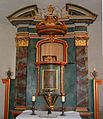 Altar Kirche Laußig AltarKircheLaussig.JPG 1,518 × 1,761; 489 KB
-
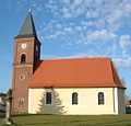 Kirche Laußig KircheLaussig.JPG 800 × 767; 112 KB
-
 Laussig Kirche.jpg 5,281 × 3,961; 7.62 MB
-
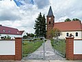
 LaußigKirche Ausschnitt.jpg 2,864 × 1,784; 590 KB
-
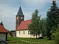 LaußigKirche.jpg 2,864 × 2,144; 511 KB


