Category:Prospect Street Historic District
Jump to navigation
Jump to search
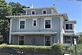
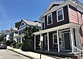
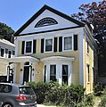
English: The Prospect Street Historic District encompasses approximately 5.5 acres northwest of the central business district of New London, Connecticut. The district is bounded by Bulkeley Place on the north, Hempstead Street on the west, Federal Street on the south and Huntington Street on the east, with the exception of 116 Federal Street on the south side of the street. Prospect Street bisects the district on a north-south axis. The residential area includes 24 buildings, most of which are Greek Revival or Italianate houses built between 1838 and 1859. The area was developed in response to local demand for increased middle-class housing, and the dense development and modest scale of the buildings is reflective of this objective. The district was listed on the National Register of Historic Places in 1986.
{Description source: NRHP)
|
This is a category about a place or building that is listed on the National Register of Historic Places in the United States of America. Its reference number is 86002114. |
historic district in Connecticut, United States  | |||||
| Upload media | |||||
| Instance of | |||||
|---|---|---|---|---|---|
| Location | New London, Southeastern Connecticut Planning Region, Connecticut | ||||
| Architectural style | |||||
| Heritage designation |
| ||||
| Elevation above sea level |
| ||||
 | |||||
Subcategories
This category has only the following subcategory.
2
Media in category "Prospect Street Historic District"
The following 16 files are in this category, out of 16 total.
-
 10 Prospect Street, Alonzo Sholes House, New London.jpg 3,351 × 3,023; 2.21 MB
-
 127 Federal Street, Peter C. Turner House, New London.jpg 2,951 × 1,995; 1.15 MB
-
 13 Prospect Street, John P. King House, New London.jpg 2,660 × 2,521; 1.52 MB
-
 138 Huntington Street, Joseph C. Douglass House, New London.jpg 2,453 × 1,896; 1.66 MB
-
 144 & 146 Huntington Street, New London.jpg 3,225 × 1,901; 1.73 MB
-
 16 Prospect Street, New London.jpg 2,598 × 2,887; 1.75 MB
-
 17 Prospect Street, New London.jpg 2,837 × 2,738; 2.3 MB
-
 19 Prospect Street, William Holt House, New London.jpg 2,908 × 2,437; 2.02 MB
-
 191 Hempstead Street, New London.jpg 2,900 × 3,255; 1.87 MB
-
 20 Prospect Street, Avery Lamb House, New London.jpg 2,722 × 2,944; 1.53 MB
-
 2022 Prospect Street east side, New London.jpg 3,950 × 2,819; 2.18 MB
-
 3 Prospect Street, New London.jpg 3,417 × 2,950; 1.7 MB
-
 34 Bulkeley Place, New London.jpg 2,987 × 2,353; 1.26 MB
-
 7 Prospect Street, Joseph Skinner 2nd House, New London.jpg 2,530 × 2,542; 1.86 MB
-
 9 Prospect Street, Abel M. Rogers House, New London.jpg 2,627 × 2,121; 1.05 MB
-
 Prospect Street Historic District, New London CT.jpg 3,072 × 2,304; 2.35 MB


Categories:
- National Register of Historic Places in New London County, Connecticut
- Historic districts in New London, Connecticut
- Greek Revival architecture in Connecticut
- Italianate architecture in Connecticut
- Gothic Revival architecture in Connecticut
- Queen Anne architecture in Connecticut
- Federal architecture in Connecticut
- Houses in New London, Connecticut
- Prospect Street (New London, Connecticut)
- Federal Street (New London, Connecticut)
- Huntington Street (New London, Connecticut)
- Hempstead Street (New London, Connecticut)