Category:Prinzenallee 46a (Berlin-Gesundbrunnen)
Jump to navigation
Jump to search
| Object location | | View all coordinates using: OpenStreetMap |
|---|
 | |||||
| Upload media | |||||
| Instance of | |||||
|---|---|---|---|---|---|
| Location | Borough of Wedding, Berlin, Germany | ||||
 | |||||
Media in category "Prinzenallee 46a (Berlin-Gesundbrunnen)"
The following 12 files are in this category, out of 12 total.
-
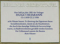
 Berlin GTafel Heimann.jpg 1,530 × 1,110; 179 KB
-
 Gedenktafel Prinzenallee 46a (Gesu) Hugo Heimann.jpg 2,153 × 1,577; 5.4 MB
-
 Gesundbrunnen Prinzenalle 46A Rote Häuser.jpg 2,152 × 848; 823 KB
-
 Gesundbrunnen Prinzenallee 46a-001.jpg 4,896 × 3,672; 6.76 MB
-
 Gesundbrunnen Prinzenallee 46a-002.jpg 3,672 × 4,896; 6.97 MB
-
 Gesundbrunnen Prinzenallee 46a-003.jpg 4,896 × 3,672; 7.25 MB
-
 Gesundbrunnen Prinzenallee 46a-004.jpg 4,896 × 3,672; 6.54 MB
-
 Gesundbrunnen Prinzenallee 46a-005.jpg 4,896 × 3,672; 6.98 MB
-
 Gesundbrunnen Prinzenallee 46a-006.jpg 4,896 × 3,672; 7.04 MB
-
 Gesundbrunnen Prinzenallee 46a-007.jpg 4,896 × 3,672; 7.31 MB
-
 Gesundbrunnen Prinzenallee 46a-008.jpg 4,014 × 3,489; 7.62 MB
-
 Gesundbrunnen Prinzenallee 46a.jpg 4,896 × 3,672; 7 MB

_Hugo_Heimann.jpg)


