Category:Price Street bridge, Birkenhead
Jump to navigation
Jump to search
| Object location | | View all coordinates using: OpenStreetMap |
|---|
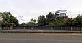
Carries Price Street, Birkenhead over the disused Birkenhead Dock Branch of the Birkenhead and Chester Railway.
Media in category "Price Street bridge, Birkenhead"
The following 3 files are in this category, out of 3 total.
-
 Benchmark at Price Street bridge, Birkenhead.jpg 4,092 × 2,348; 5.44 MB
-
 Price Street bridge 1.jpg 4,772 × 2,336; 5.24 MB
-
 Price Street bridge 2.jpg 4,920 × 2,600; 5.88 MB


