Category:Prawle Point
Jump to navigation
Jump to search
headland in Devon, England  | |||||
| Upload media | |||||
| Instance of | |||||
|---|---|---|---|---|---|
| Location | Chivelstone, South Hams, Devon, South West England, England | ||||
 | |||||
Media in category "Prawle Point"
The following 46 files are in this category, out of 46 total.
-
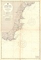 Admiralty Chart No 1613 Prawle Point to Straight Point, Published 1955.jpg 11,080 × 16,140; 13 MB
-
 Admiralty Chart No 2454 Prawle Point to Hengistbury Head, Published 1967.jpg 12,299 × 8,470; 22.13 MB
-
 Approaching Prawle Point - geograph.org.uk - 423080.jpg 640 × 480; 51 KB
-
 Cairn at Prawle Point.jpg 5,152 × 3,864; 10.75 MB
-
 Chivelstone, towards Prawle Point - geograph.org.uk - 1316904.jpg 640 × 427; 454 KB
-
 Coastal path at Prawle Point - geograph.org.uk - 1562318.jpg 640 × 480; 70 KB
-

-
 Coastline east from Prawle Point - geograph.org.uk - 845271.jpg 640 × 480; 104 KB
-
 Coastline east of Prawle Point - geograph.org.uk - 3903544.jpg 4,000 × 3,000; 1.87 MB
-
 East side of Prawle Point - geograph.org.uk - 845273.jpg 480 × 640; 107 KB
-
 Footpath Sign, Prawle Point - geograph.org.uk - 423059.jpg 640 × 480; 77 KB
-
 Inlet in Western Cove - geograph.org.uk - 2633380.jpg 600 × 800; 461 KB
-
 Maceley Cove - geograph.org.uk - 4918115.jpg 600 × 800; 170 KB
-
 National Coastwatch Prawle Point.jpg 5,152 × 3,864; 8.67 MB
-
 On Prawle Point - geograph.org.uk - 845313.jpg 640 × 480; 91 KB
-
 On the way to Prawle Point - geograph.org.uk - 4427355.jpg 2,592 × 1,944; 655 KB
-
 Ordnance Survey Sheet SX 73 Salcombe, Published 1968.jpg 14,827 × 7,000; 36.68 MB
-
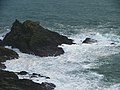 Outer Rocks, Prawle Point - geograph.org.uk - 76604.jpg 640 × 480; 108 KB
-
 Prawle Point (24317376863).jpg 6,000 × 4,000; 9.91 MB
-
 Prawle Point (24936479535).jpg 6,000 × 4,000; 6.92 MB
-
 Prawle Point - geograph.org.uk - 1577759.jpg 640 × 480; 96 KB
-
 Prawle Point - geograph.org.uk - 1656629.jpg 640 × 428; 98 KB
-
 Prawle Point - geograph.org.uk - 1732042.jpg 640 × 480; 103 KB
-
 Prawle Point - geograph.org.uk - 277282.jpg 640 × 480; 81 KB
-
 Prawle Point - geograph.org.uk - 31285.jpg 640 × 442; 79 KB
-
 Prawle Point - geograph.org.uk - 340609.jpg 640 × 480; 79 KB
-
 Prawle point - geograph.org.uk - 423075.jpg 640 × 480; 44 KB
-
 Prawle Point - geograph.org.uk - 8698.jpg 640 × 480; 74 KB
-
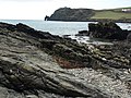
 Prawle Point Coastline - geograph.org.uk - 8696.jpg 640 × 480; 80 KB
-
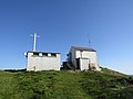
 Prawle Point Coastwatch Station - geograph.org.uk - 372419.jpg 640 × 480; 94 KB
-
 Prawle Point Cottages - geograph.org.uk - 845265.jpg 640 × 440; 101 KB
-
 Prawle point footpath - geograph.org.uk - 423055.jpg 480 × 640; 95 KB
-
 Prawle Point from Gammon Head Panorama.jpg 10,279 × 5,192; 44.78 MB
-
 Prawle Point from Lane.jpg 5,152 × 3,864; 9.13 MB
-
 Prawle Point from Peartree Point (3137).jpg 4,288 × 2,848; 4.51 MB
-
 Prawle Point.jpg 3,839 × 2,696; 3.75 MB
-
 Rock on Prawle Point - geograph.org.uk - 845304.jpg 640 × 606; 110 KB
-
 Sheep's-bit, Prawle Point - geograph.org.uk - 845277.jpg 640 × 466; 108 KB
-
 Towards Prawle Point - geograph.org.uk - 5811278.jpg 4,288 × 2,848; 1.67 MB
-
 View from Great Mattiscombe Sand to Prawle Point (3086).jpg 4,288 × 2,848; 6.7 MB
-
 View from Great Mattiscombe Sand to Prawle Point (3087).jpg 4,288 × 2,848; 6.14 MB
-
 View from Limpet Cove to Prawle Point (3092).jpg 4,288 × 2,848; 6.31 MB
-
 View to Prawle Point from Peartree Point (3136).jpg 4,288 × 2,848; 6.85 MB
-
 View to the east from Prawle Point - geograph.org.uk - 4919597.jpg 1,024 × 768; 295 KB
-
 View towards Prawle Point (geograph 4918462).jpg 800 × 600; 177 KB
-
 Wall near Prawle Point - geograph.org.uk - 845340.jpg 640 × 480; 131 KB


.jpg)
.jpg)


.jpg)


.jpg)
.jpg)
.jpg)
.jpg)

.jpg)
