Category:Prairie Dog Golf Course lattice truss bridge (Norton, Kansas)
Jump to navigation
Jump to search
| Object location | | View all coordinates using: OpenStreetMap |
|---|
relocated road bridge in Norton County, Kansas  | |||||
| Upload media | |||||
| Instance of | |||||
|---|---|---|---|---|---|
| Made from material | |||||
| Location | Norton, Norton County, Kansas | ||||
| Main building contractor | |||||
| Heritage designation |
| ||||
| Inception |
| ||||
| Significant event |
| ||||
 | |||||
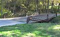
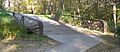
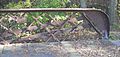
Listed in the National Register of Historic Places as "North Fork Solomon River Lattice Truss Bridge". Originally spanned the North Fork of the Solomon ca. 1.5 miles west of Lenora, Kansas; moved to Prairie Dog Golf Course on the outskirts of Norton, Kansas, in 2006. See Norton Telegram, 2007-01-09, p. 3; retrieved 2014-09-21; and "National Register of Historic Places Registration Form: Amendment", retrieved 2014-09-21.
Media in category "Prairie Dog Golf Course lattice truss bridge (Norton, Kansas)"
The following 13 files are in this category, out of 13 total.
-
 Prairie Dog Golf Course lattice truss bridge center detail 1.JPG 2,541 × 1,215; 878 KB
-
 Prairie Dog Golf Course lattice truss bridge center detail 2.JPG 1,795 × 1,434; 974 KB
-
 Prairie Dog Golf Course lattice truss bridge center section 2.JPG 1,657 × 2,060; 850 KB
-
 Prairie Dog Golf Course lattice truss bridge flower 1.JPG 1,455 × 1,280; 498 KB
-
 Prairie Dog Golf Course lattice truss bridge from N 1.JPG 2,169 × 1,347; 1.13 MB
-
 Prairie Dog Golf Course lattice truss bridge from NE 1.JPG 2,088 × 1,059; 607 KB
-
 Prairie Dog Golf Course lattice truss bridge from NW 1.JPG 2,162 × 946; 721 KB
-
 Prairie Dog Golf Course lattice truss bridge from SW 1.JPG 2,196 × 959; 704 KB
-
 Prairie Dog Golf Course lattice truss bridge from SW 2.JPG 2,182 × 1,347; 983 KB
-
 Prairie Dog Golf Course lattice truss bridge NW truss 1.JPG 1,069 × 2,096; 589 KB
-
 Prairie Dog Golf Course lattice truss bridge NW truss 2.JPG 1,959 × 1,167; 750 KB
-
 Prairie Dog Golf Course lattice truss bridge plaque 1.JPG 2,339 × 1,624; 1,009 KB
-
 Prairie Dog Golf Course lattice truss bridge S corner 1.JPG 2,178 × 1,030; 802 KB


