Category:Poulton-le-Fylde
Jump to navigation
Jump to search
town in Lancashire, United Kingdom  Eglwys Sant Chad, Poulton-le-Fylde | |||||
| Upload media | |||||
| Instance of | |||||
|---|---|---|---|---|---|
| Location | Wyre, Lancashire, North West England, England | ||||
 | |||||
English: Poulton-le-Fylde (commonly shortened by locals to just Poulton) is a town within the Wyre borough of Lancashire, England. The town has a population of 19,480 as of 2001 and occupies an area of 7.79 km², for a population density of 2500 people/km². It is situated about 5 kilometres to the northeast of Blackpool town and the Irish Sea coast.
Nederlands: Poulton-le-Fylde is een plaats in het bestuurlijke gebied Wyre, in het Engelse graafschap Lancashire. De plaats telt 19.480 inwoners.
Română: Poulton-le-Fylde este un oraş în comitatul Lancashire, regiunea North West, Anglia. Oraşul se află în districtul Wyre a cărui reşedinţă este.
Simple English: Poulton-le-Fylde is a town in the Wyre borough of Lancashire, England. As of 2001, 19,480 people lived there.
Subcategories
This category has the following 5 subcategories, out of 5 total.
Media in category "Poulton-le-Fylde"
The following 91 files are in this category, out of 91 total.
-
 2 Market Place 2024 2.jpg 4,032 × 3,024; 3.47 MB
-
 2 Market Square, Poulton-le-Fylde.jpg 3,783 × 2,837; 7.16 MB
-
 25-33 Market Place.jpg 5,378 × 4,284; 5.92 MB
-
 Archway Travel 2024.jpg 4,371 × 2,844; 2.49 MB
-
 Ball Street 2023.jpg 4,032 × 3,024; 3.04 MB
-
 Ball Street Poulton 2024.jpg 5,712 × 4,284; 6.73 MB
-
 Blackpool Old Road at Market Square.jpg 5,712 × 4,284; 6.09 MB
-
 BlackpoolBUA.png 413 × 850; 422 KB
-
 Breck Lodge.jpg 5,712 × 4,284; 8.8 MB
-
 Brockholes Wood - geograph.org.uk - 808850.jpg 640 × 480; 87 KB
-
 Bull Street, Poulton-le-Fylde.jpg 640 × 427; 43 KB
-
 Bungalows and Fields - geograph.org.uk - 897288.jpg 640 × 480; 80 KB
-
 Burlington Street (former location of), Poulton-le-Fylde.jpg 4,032 × 3,024; 3.94 MB
-
 Carleton Crossroads - geograph.org.uk - 1534127.jpg 640 × 426; 54 KB
-
 Chapel Street Brewery 2024 1.jpg 4,032 × 3,024; 3.77 MB
-
 Chapel Street Brewery 2024 2.jpg 4,284 × 5,712; 8.71 MB
-
 Church Street Poulton 2023.jpg 3,024 × 4,032; 5.07 MB
-
 Church Street Poulton 2024.jpg 3,024 × 4,032; 3.52 MB
-
 Church Street, Poulton-le-Fylde.png 1,264 × 846; 898 KB
-
 DEMThompson, Poulton-le-Fylde.jpg 2,388 × 3,184; 4.79 MB
-
 DEMThomson, Poulton-le-Fylde.jpg 3,852 × 2,889; 6.04 MB
-
 Disused Rail line - geograph.org.uk - 68937.jpg 640 × 480; 110 KB
-
 Dried Up Pond - geograph.org.uk - 1533875.jpg 640 × 426; 90 KB
-
 End Cottage, Poulton-le-Fylde.JPG 3,690 × 2,767; 7.09 MB
-
 Fish slabs, Poulton-le-Fylde.jpg 3,706 × 2,779; 7.16 MB
-
 Fleetwood branch line.jpg 3,350 × 3,615; 3.57 MB
-

-
 Fox's Farmhouse, Poulton-le-Fylde.jpg 3,313 × 2,485; 4.35 MB
-
 Golden Ball rear 2024.jpg 3,564 × 2,599; 2.24 MB
-
 Harvester - geograph.org.uk - 1386647.jpg 640 × 480; 54 KB
-
 Hesketh family vault.jpg 3,856 × 5,475; 6.96 MB
-
 Houses at Hardhorn near Blackpool - geograph.org.uk - 1413874.jpg 640 × 480; 46 KB
-

-
 Market Place buildings, Poulton-le-Fylde.jpg 3,548 × 2,661; 5.08 MB
-
 Market Place, Poulton-le-Fylde - geograph.org.uk - 963250.jpg 640 × 480; 195 KB
-
 Market Place, Poulton-le-Fylde - geograph.org.uk - 964680.jpg 640 × 480; 194 KB
-
 Natwest bank, Poulton-le-Fylde.jpg 2,659 × 3,545; 6.57 MB
-
 Natwest bank, Poulton-le-Fylde2.jpg 3,968 × 2,976; 5.59 MB
-

-
 Old Bus Stop - geograph.org.uk - 1533884.jpg 640 × 426; 86 KB
-
 Oldfield Carr Lane - geograph.org.uk - 1042389.jpg 640 × 480; 116 KB
-
 Peacock (3332708807).jpg 800 × 1,136; 847 KB
-
 Peacock gates 1 (3333111318).jpg 3,414 × 2,598; 6.92 MB
-
 Peacock gates 2 (3333087188).jpg 4,752 × 3,168; 9.64 MB
-
 Peacock gates 3 (3332268529).jpg 2,932 × 3,550; 7.99 MB
-
 Pond in the Fields - geograph.org.uk - 897280.jpg 640 × 480; 118 KB
-
 Post Office, Poulton-le-Fylde - geograph.org.uk - 963295.jpg 640 × 480; 252 KB
-
 Poulton Civic Centre - geograph.org.uk - 1269699 (crop).jpg 480 × 466; 181 KB
-
 Poulton Civic Centre - geograph.org.uk - 1269699.jpg 480 × 640; 60 KB
-
 Poulton Civic Centre from the back - geograph.org.uk - 1269670.jpg 640 × 480; 81 KB
-
 Poulton Curve Halt (site), Lancashire (geograph 5842522).jpg 1,600 × 1,200; 670 KB
-
 Poulton le Fylde library - geograph.org.uk - 366327.jpg 640 × 480; 78 KB
-
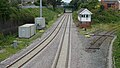
 Poulton railway station, 2023.jpg 4,032 × 3,024; 3.64 MB
-
 Poulton Savings Bank, Poulton-le-Fylde 2.jpg 2,160 × 2,880; 4.27 MB
-
 Poulton Savings Bank, Poulton-le-Fylde.jpg 1,909 × 2,545; 2.1 MB
-
 Poulton-le-Fylde Junction 2017.jpg 5,184 × 2,920; 7.25 MB
-
 Poulton-le-Fylde Junction.jpg 1,840 × 1,232; 893 KB
-
 Poulton-le-Fylde Market Place - geograph.org.uk - 5165803.jpg 1,000 × 669; 566 KB
-
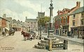 Poulton-le-Fylde nr. Blackpool, A. R. Quinton.jpg 1,441 × 903; 764 KB
-
 Preston Bus 2024 2.jpg 5,192 × 3,635; 3.35 MB
-
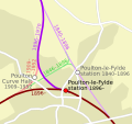 Railways in Poulton-le-Fylde.svg 744 × 700; 26 KB
-
 Red telephone box, Poulton-le-Fylde.jpg 3,711 × 2,783; 5.79 MB
-
 River Wyre pub - geograph.org.uk - 483938.jpg 480 × 640; 210 KB
-
 Road junction, Poulton-le-Fylde - geograph.org.uk - 927015.jpg 487 × 640; 89 KB
-

-
 Scout Hut - geograph.org.uk - 1534109.jpg 640 × 426; 63 KB
-
 Shops on Grange Park Estate - geograph.org.uk - 1196890.jpg 640 × 426; 98 KB
-
 St Chad S Church (69074699).jpeg 2,048 × 1,365; 821 KB
-
 St Chad's apse.jpg 4,284 × 5,712; 7.33 MB
-
 Stocks, Poulton-le-Fylde.jpg 3,534 × 2,650; 6.6 MB
-
 Teanlowe Centre 2024.jpg 4,032 × 3,024; 3.68 MB
-

-
 Thatched House Poulton 2024.jpg 5,712 × 4,284; 5.85 MB
-

-
 The Bull Poulton 2024.jpg 5,697 × 3,345; 4.48 MB
-
 The Cube Poulton 2024.jpg 4,032 × 3,024; 3.22 MB
-
 The Falcon Hotel, Poulton-le-Fylde - geograph.org.uk - 941292.jpg 640 × 407; 62 KB
-
 The Manor, Poulton-le-Fylde 2.jpg 1,879 × 2,506; 3.78 MB
-
 The Mews, Poulton-le-Fylde - geograph.org.uk - 927032.jpg 640 × 426; 85 KB
-
 The Old Cottage, Poulton-le-Fylde.jpg 2,771 × 2,078; 3.57 MB
-
 The River Wyre, Poulton-le-Fylde - geograph.org.uk - 927037.jpg 640 × 427; 70 KB
-
 The Royal Oak (former location).jpg 4,284 × 5,712; 7.26 MB
-
 The Stocks, Poulton-le-Fylde - geograph.org.uk - 927020.jpg 425 × 640; 75 KB
-

-
 Whipping post, Poulton-le-Fylde.jpg 2,712 × 3,616; 6.39 MB
-

-
 Carr Head Educational Centre - geograph.org.uk - 127481.jpg 640 × 426; 73 KB
-
 Cocker Industrial Estate - geograph.org.uk - 127484.jpg 640 × 426; 72 KB
-
 Little Poulton Lane , Poulton-le-Fylde - geograph.org.uk - 68935.jpg 640 × 480; 76 KB
-
 Queueing - geograph.org.uk - 50270.jpg 640 × 480; 163 KB
-


,_Poulton-le-Fylde.jpg)


.jpg)
.jpg)
.jpg)
.jpg)


.jpg)


,_Lancashire_(geograph_5842522).jpg)


.jpeg)


.jpg)


