Category:Porte de l'Oulle
Jump to navigation
Jump to search
| Object location | | View all coordinates using: OpenStreetMap |
|---|
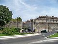
English: Porte de l'Oulle. The original 14th century name was Porte Sainte-Jacques, it later became Porte du Limas. The gate was walled up during the Wars of Religion, and opened again in 1663. Rebuilt by Jean-Baptiste Péru in 1785–1786 20 metres north of the original position, it was demolished in 1900. Oulle or Oulo is a "cooking pot" in the Provençal dialect. They were sold in a nearby market.
Media in category "Porte de l'Oulle"
The following 5 files are in this category, out of 5 total.
-

-
 Avignon destruction de la Porte de l'Oulle.jpg 856 × 1,000; 447 KB
-
 Porte de L'Ouille.JPG 4,000 × 3,000; 2.16 MB
-
 Porte de l'Oulle AMA 8Fi3162.jpg 2,444 × 1,696; 363 KB
-
 Porte de l'OUlle avant démolition.jpg 972 × 640; 789 KB


