Category:Population density maps of Poland
Jump to navigation
Jump to search
Subcategories
This category has only the following subcategory.
Media in category "Population density maps of Poland"
The following 14 files are in this category, out of 14 total.
-

-
 56 of Longmans' Junior School Geography, etc. (11214144254).jpg 2,704 × 2,001; 1.75 MB
-
 Einwohnerentwicklung von Lublin.svg 800 × 400; 24 KB
-
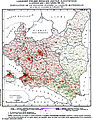 GUS languages1931 Poland.jpg 2,152 × 2,796; 4.1 MB
-
 Gęstość zaludnienia w Polsce w 2016 roku (Silesia).png 2,477 × 3,195; 622 KB
-
 Gęstość zaludnienia w Polsce w 2016 roku.png 7,000 × 6,500; 5.37 MB
-
 Izoplety1.jpg 807 × 581; 161 KB
-
 Lange diercke sachsen deutschland dichte der bevoelkerung.jpg 1,248 × 1,054; 570 KB
-
 Poland Population Density, 2000 (5457017737).jpg 2,502 × 3,265; 674 KB
-
 Poland Population Density, 2000 (6171916441).jpg 2,396 × 3,161; 730 KB
-
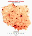 Population density in Poland.png 1,350 × 1,500; 426 KB
-
 Population density of Poland voivodeships.png 5,191 × 4,441; 686 KB
-
 Population density of Poland.png 3,248 × 2,834; 9.25 MB
-
 Плотность населения Польши.png 1,461 × 1,120; 539 KB
.jpg)
.jpg)


.png)


.jpg)
.jpg)


