Category:Ponte do século XVII sobre o Rio Jamor
Jump to navigation
Jump to search
|
This monument is classified as
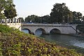
IIM - Imóvel de Interesse Municipal .It is indexed in the IGESPAR database ( Instituto de Gestão do Património Arquitectónico e Arqueológico ), under the reference 70906.It is indexed in the SIPA database (Sistema de Informação para o Património Arquitectónico) under the reference 4810. |
| Object location | | View all coordinates using: OpenStreetMap |
|---|
cultural heritage monument in Oeiras, Portugal  | |||||
| Upload media | |||||
| Instance of | |||||
|---|---|---|---|---|---|
| Location | Cruz Quebrada - Dafundo, Algés, Linda-a-Velha e Cruz Quebrada-Dafundo, Oeiras, Lisbon, Portugal | ||||
| Heritage designation | |||||
 | |||||
Media in category "Ponte do século XVII sobre o Rio Jamor"
This category contains only the following file.
-
 Ponte séc XVII.jpg 4,608 × 3,072; 4.29 MB