Category:Pont de la Tine (Vers le Pont, Rossinière)
Jump to navigation
Jump to search
| Object location | | View all coordinates using: OpenStreetMap |
|---|
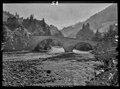
stone bridge over the Saane/Sarine in Rossinière in the canton of Vaud, Switzerland  | |||||
| Upload media | |||||
| Instance of | |||||
|---|---|---|---|---|---|
| Part of | |||||
| Made from material | |||||
| Location | Rossinière, Riviera-Pays-d'Enhaut District, canton Vaud, Switzerland | ||||
| Street address |
| ||||
| Crosses | |||||
| Heritage designation | |||||
 | |||||
Media in category "Pont de la Tine (Vers le Pont, Rossinière)"
The following 2 files are in this category, out of 2 total.
-
 CH-NB Photoglob-Wehrli EAD-WEHR-4788-B.tif 7,353 × 5,463, 2 pages; 76.68 MB
-
 Vieux Pont de la Tine-Brücke über die Saane, La Tine VD 20220508-jag9889.jpg 3,950 × 3,160; 8.22 MB