Category:Pont de ferro (Albalat)
Jump to navigation
Jump to search
| Object location | | View all coordinates using: OpenStreetMap |
|---|
bridge in Spain  | |||||
| Upload media | |||||
| Instance of | |||||
|---|---|---|---|---|---|
| Location | |||||
| Crosses | |||||
| Heritage designation |
| ||||
| Significant event |
| ||||
 | |||||
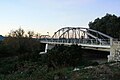
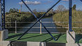
This is a category about a building listed in the Valencian heritage register as Bé de Rellevància Local (BRL) under the reference 46.21.008-010. |
Media in category "Pont de ferro (Albalat)"
The following 4 files are in this category, out of 4 total.
-
 Pont d'Albalat.jpg 567 × 378; 32 KB
-
 Pont dalt del riu Xúquer (Albalat de la Ribera-País Valencià).jpg 3,592 × 1,936; 2.09 MB
-
 Pont damunt del riu Xúquer (Albalat de la Ribera-País Valencià).jpg 1,852 × 3,172; 1.84 MB
-
 Riu Xúquer (Albalat de la Ribera-País Valencià).jpg 3,604 × 2,038; 2.28 MB
.jpg)
.jpg)
.jpg)