Category:Pont couvert sur la Drance (La Bâtiaz, Martigny)
Jump to navigation
Jump to search
| Object location | | View all coordinates using: OpenStreetMap |
|---|
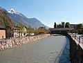
covered wooden bridge in Martigny in the canton of Valais, Switzerland  | |||||
| Upload media | |||||
| Instance of | |||||
|---|---|---|---|---|---|
| Part of | |||||
| Location |
| ||||
| Street address |
| ||||
| Crosses | |||||
| Heritage designation | |||||
 | |||||
Media in category "Pont couvert sur la Drance (La Bâtiaz, Martigny)"
The following 2 files are in this category, out of 2 total.
-
 Dranse Martigny.jpg 1,632 × 1,232; 744 KB
-
 Gedeckte Brücke über die Dranse 2013-09-29 13-35-34.jpg 4,128 × 2,322; 4.19 MB
