Category:Ponlachgraben
Jump to navigation
Jump to search
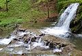
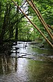
Deutsch: Der Ponlachgraben ist ein westlich der Tittmoninger Burg gelegenes bewaldetes Tal, in dem von West nach Ost die Ponlach verläuft.
Media in category "Ponlachgraben"
The following 20 files are in this category, out of 20 total.
-
 Ponlachgraben 1.jpg 2,522 × 1,745; 2.43 MB
-
 Ponlachgraben 10.jpg 3,456 × 5,184; 10.06 MB
-
 Ponlachgraben 11.jpg 5,184 × 3,456; 10.25 MB
-
 Ponlachgraben 12.jpg 5,170 × 3,434; 8.66 MB
-
 Ponlachgraben 13.jpg 3,452 × 5,182; 9.17 MB
-
 Ponlachgraben 14.jpg 3,456 × 5,184; 7.28 MB
-
 Ponlachgraben 15.jpg 5,090 × 3,310; 8.33 MB
-
 Ponlachgraben 16.jpg 3,262 × 5,058; 7.75 MB
-
 Ponlachgraben 17.jpg 3,456 × 5,184; 8.38 MB
-
 Ponlachgraben 18.jpg 3,352 × 5,116; 9.14 MB
-
 Ponlachgraben 19.jpg 3,456 × 5,184; 12.32 MB
-
 Ponlachgraben 2.jpg 2,650 × 1,835; 2.62 MB
-
 Ponlachgraben 20.jpg 3,260 × 5,060; 8.33 MB
-
 Ponlachgraben 3.jpg 2,751 × 1,835; 3.17 MB
-
 Ponlachgraben 4.jpg 2,739 × 1,826; 2.94 MB
-
 Ponlachgraben 5.jpg 5,176 × 3,444; 7.02 MB
-
 Ponlachgraben 6.jpg 5,184 × 3,456; 12.92 MB
-
 Ponlachgraben 7.jpg 4,986 × 3,140; 7.16 MB
-
 Ponlachgraben 8.jpg 5,184 × 3,456; 8.09 MB
-
 Ponlachgraben 9.jpg 5,122 × 3,362; 6.71 MB


