Category:Political maps of Ottawa County, Ohio as of the 2000 United States Census
Jump to navigation
Jump to search
Media in category "Political maps of Ottawa County, Ohio as of the 2000 United States Census"
The following 24 files are in this category, out of 24 total.
-
 Allen Twp Ottawa OH.JPG 834 × 525; 39 KB
-
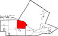
 Map of Ottawa County Ohio Highlighting Allen Township.png 850 × 531; 31 KB
-
 Map of Ottawa County Ohio Highlighting Bay Township.png 850 × 531; 31 KB
-
 Map of Ottawa County Ohio Highlighting Benton Township.png 850 × 531; 31 KB
-
 Map of Ottawa County Ohio Highlighting Carroll Township.png 850 × 531; 31 KB
-
 Map of Ottawa County Ohio Highlighting Catawba Island Township.png 850 × 531; 31 KB
-
 Map of Ottawa County Ohio Highlighting Clay Center Village.png 850 × 531; 31 KB
-
 Map of Ottawa County Ohio Highlighting Clay Township.png 850 × 531; 31 KB
-
 Map of Ottawa County Ohio Highlighting Danbury Township.png 850 × 531; 31 KB
-
 Map of Ottawa County Ohio Highlighting Elmore Village.png 850 × 531; 31 KB
-
 Map of Ottawa County Ohio Highlighting Erie Township.png 850 × 531; 31 KB
-
 Map of Ottawa County Ohio Highlighting Genoa Village.png 850 × 531; 31 KB
-
 Map of Ottawa County Ohio Highlighting Harris Township.png 850 × 531; 31 KB
-
 Map of Ottawa County Ohio Highlighting Marblehead Village.png 850 × 531; 31 KB
-
 Map of Ottawa County Ohio Highlighting Oak Harbor Village.png 850 × 531; 31 KB
-
 Map of Ottawa County Ohio Highlighting Port Clinton City.png 850 × 531; 31 KB
-
 Map of Ottawa County Ohio Highlighting Portage Township.png 850 × 531; 31 KB
-
 Map of Ottawa County Ohio Highlighting Put-in-Bay Township.png 850 × 531; 31 KB
-
 Map of Ottawa County Ohio Highlighting Put-in-Bay Village.png 850 × 531; 31 KB
-
 Map of Ottawa County Ohio Highlighting Rocky Ridge Village.png 850 × 531; 31 KB
-
 Map of Ottawa County Ohio Highlighting Salem Township.png 850 × 531; 31 KB
-
 Map of Ottawa County Ohio With Municipal and Township Labels.PNG 850 × 531; 49 KB
-
 Map of Ottawa County, Ohio No Text, Municipalities Distinct.png 850 × 531; 31 KB
-
 Map of Ottawa County, Ohio No Text.png 850 × 531; 30 KB


