Category:Political maps of Clermont County, Ohio as of the 2000 United States Census
Jump to navigation
Jump to search
Media in category "Political maps of Clermont County, Ohio as of the 2000 United States Census"
The following 30 files are in this category, out of 30 total.
-
 Map of Clermont County Ohio Highlighting Amelia Village.png 471 × 741; 35 KB
-
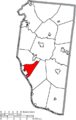
 Map of Clermont County Ohio Highlighting Batavia Township.png 471 × 741; 35 KB
-
 Map of Clermont County Ohio Highlighting Batavia Village.png 471 × 741; 35 KB
-
 Map of Clermont County Ohio Highlighting Bethel Village.png 471 × 741; 35 KB
-
 Map of Clermont County Ohio Highlighting Chilo Village.png 471 × 741; 35 KB
-
 Map of Clermont County Ohio Highlighting Felicity Village.png 471 × 741; 35 KB
-
 Map of Clermont County Ohio Highlighting Franklin Township.png 471 × 741; 35 KB
-
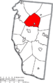
 Map of Clermont County Ohio Highlighting Goshen Township.png 471 × 741; 35 KB
-
 Map of Clermont County Ohio Highlighting Jackson Township.png 471 × 741; 35 KB
-
 Map of Clermont County Ohio Highlighting Loveland City.png 471 × 741; 35 KB
-
 Map of Clermont County Ohio Highlighting Miami Township.png 471 × 741; 35 KB
-
 Map of Clermont County Ohio Highlighting Milford City.png 471 × 741; 35 KB
-
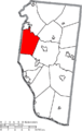
 Map of Clermont County Ohio Highlighting Monroe Township.png 471 × 741; 35 KB
-
 Map of Clermont County Ohio Highlighting Moscow Village.png 471 × 741; 35 KB
-
 Map of Clermont County Ohio Highlighting Neville Village.png 471 × 741; 35 KB
-
 Map of Clermont County Ohio Highlighting New Richmond Village.png 471 × 741; 35 KB
-
 Map of Clermont County Ohio Highlighting Newtonsville Village.png 471 × 741; 35 KB
-
 Map of Clermont County Ohio Highlighting Ohio Township.png 471 × 741; 35 KB
-
 Map of Clermont County Ohio Highlighting Owensville Village.png 471 × 741; 35 KB
-
 Map of Clermont County Ohio Highlighting Pierce Township.png 471 × 741; 35 KB
-
 Map of Clermont County Ohio Highlighting Stonelick Township.png 471 × 741; 35 KB
-
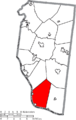
 Map of Clermont County Ohio Highlighting Tate Township.png 471 × 741; 35 KB
-
 Map of Clermont County Ohio Highlighting Union Township.png 471 × 741; 35 KB
-
 Map of Clermont County Ohio Highlighting Washington Township.png 471 × 741; 35 KB
-
 Map of Clermont County Ohio Highlighting Wayne Township.png 471 × 741; 35 KB
-
 Map of Clermont County Ohio Highlighting Williamsburg Township.png 471 × 741; 35 KB
-
 Map of Clermont County Ohio Highlighting Williamsburg Village.png 471 × 741; 35 KB
-
 Map of Clermont County Ohio With Municipal and Township Labels.PNG 471 × 741; 58 KB
-
 Map of Clermont County, Ohio No Text, Municipalities Distinct.png 471 × 741; 35 KB
-
 Map of Clermont County, Ohio No Text.png 471 × 741; 35 KB


