Category:Political charts of Třebíč
Jump to navigation
Jump to search
Wikimedia category | |||||
| Upload media | |||||
| Instance of | |||||
|---|---|---|---|---|---|
| Category combines topics | |||||
| Třebíč | |||||
town in Vysočina Region, Czech Republic  Třebíč-Vnitřní Město. Pohled do centra     | |||||
| Instance of |
| ||||
| Location |
| ||||
| Located in or next to body of water | |||||
| Diocese | |||||
| Official language | |||||
| Head of government |
| ||||
| Has part(s) |
| ||||
| Legal form | |||||
| Founded by | |||||
| Inception |
| ||||
| Highest point |
| ||||
| Population |
| ||||
| Area |
| ||||
| Elevation above sea level |
| ||||
| Different from | |||||
| official website | |||||
 | |||||
Media in category "Political charts of Třebíč"
The following 24 files are in this category, out of 24 total.
-
 High Schools in Třebíči in 2009 data, pie charts.svg 1,000 × 750; 543 KB
-
 Image-Třebíč, počet obyvatel 1970 - 2007.png 659 × 398; 18 KB
-

-

-

-
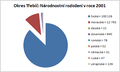
 Pie chart of number of population by city districts in Třebíč in 2001.svg 1,371 × 888; 333 KB
-
 Plot of population in 1655 - 2009 in Třebíč, Czech Republic.1.svg 733 × 553; 74 KB
-
 Plot of population in 1655 - 2009 in Třebíč, Czech Republic.svg 1,250 × 800; 195 KB
-
 Schools in Třebíč at 1906 data, pie charts.svg 1,000 × 750; 733 KB
-
 Tr-obyv001.png 750 × 451; 13 KB
-
 Tr-pocasi.png 824 × 634; 7 KB
-
 Tr-pocasi001.png 816 × 558; 7 KB
-
 Třebíč municipal assembly election plot 1931.svg 630 × 440; 34 KB
-
 Třebíč municipal assembly election plot 1938.svg 630 × 440; 35 KB
-
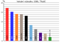
 Třebíč municipal assembly election plot 1990.svg 630 × 440; 93 KB
-
 Třebíč municipal assembly election plot 1994.svg 630 × 440; 103 KB
-
 Třebíč municipal assembly election plot 1998.svg 630 × 440; 103 KB
-
 Třebíč raining 1993-2001.png 3,022 × 1,943; 284 KB
-
 Třebíč weather.png 2,998 × 2,007; 235 KB
-
 Třebíč, místní části, 2001.png 1,371 × 888; 59 KB
-
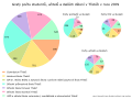
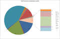
 Třebíč, národnost, 2001.png 483 × 291; 13 KB
-
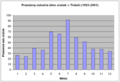
 Třebíč, počet obyvatel 1763 - 2005.png 659 × 397; 21 KB
-
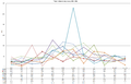
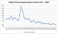 Třebíč, přirozený přírůstek, 1970 - 2007.png 659 × 397; 21 KB
-
 Třebíč, zastupitelstvo 1994-2006.png 1,361 × 851; 60 KB


