Category:Plimsoll Bridge
Jump to navigation
Jump to search
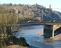
Plimsoll Bridge, across the entrance to Cumberland Basin, Bristol
Media in category "Plimsoll Bridge"
The following 25 files are in this category, out of 25 total.
-

-

-
 Bristol shield plimsoll.jpg 4,024 × 2,634; 1,012 KB
-
 Bristol Docks.jpg 4,984 × 5,031; 14.74 MB
-
 Bristol MMB «W5 Cumberland Basin.jpg 4,579 × 2,760; 3.45 MB
-
 Brunel's lock bridge, beneath Plimsoll Bridge.jpg 4,000 × 2,214; 1.05 MB
-
 Clift House Road in Ashton - geograph.org.uk - 2470386.jpg 1,500 × 1,000; 163 KB
-
 Control room, Plimsoll Bridge, Bristol - geograph.org.uk - 3793546.jpg 640 × 517; 146 KB
-
 Cumberland Basin and Plimsoll Bridge - geograph.org.uk - 141947.jpg 640 × 480; 112 KB
-

-
 Cumberland basin swing bridge at work - geograph.org.uk - 767419.jpg 640 × 426; 52 KB
-
 Entrance lock to the Cumberland Basin - geograph.org.uk - 5446388.jpg 1,280 × 929; 297 KB
-
 Hotwells - BS8 - geograph.org.uk - 3098655.jpg 800 × 556; 133 KB
-
 Hotwells - BS8 - geograph.org.uk - 3098711.jpg 800 × 621; 156 KB
-
 On the Plimsoll Bridge (3) - geograph.org.uk - 6443565.jpg 3,013 × 2,867; 4.15 MB
-
 Plimsoll Swing Bridge - Cumberland Basin - geograph.org.uk - 1011770.jpg 640 × 480; 104 KB
-
 Plimsoll Swing Bridge - geograph.org.uk - 142532.jpg 640 × 480; 120 KB
-
 Ramp down from the Swing Bridge - geograph.org.uk - 130042.jpg 640 × 480; 136 KB
-
 The control tower on the Plimsoll Bridge - geograph.org.uk - 2472136.jpg 1,500 × 1,000; 174 KB
-
 The Plimsoll Bridge almost closed - Bristol Harbour - geograph.org.uk - 1866844.jpg 3,265 × 2,231; 2.43 MB
-
 Top gates closing, Entrance Lock, Bristol (1) - geograph.org.uk - 4485670.jpg 1,024 × 768; 115 KB
-
 Top gates closing, Entrance Lock, Bristol (2) - geograph.org.uk - 4485673.jpg 1,024 × 768; 109 KB
-
 Tower on Plimsoll bridge, Bristol - geograph.org.uk - 5450292.jpg 1,979 × 2,613; 891 KB
-
 Under Plimsoll Bridge - geograph.org.uk - 5454177.jpg 640 × 427; 198 KB
-


_-_geograph.org.uk_-_6443565.jpg)


_-_geograph.org.uk_-_4485670.jpg)
_-_geograph.org.uk_-_4485673.jpg)


