Category:Pletiu de Riumalo
Jump to navigation
Jump to search
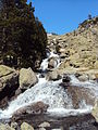
Català: Pletiu de Riumalo o Planell de Riumalo, extens planell a la Capçalera de Caldes, aigües amunt de l'embassament de Cavallers, on conflueixen els barrancs de Malavesina, el de les Llastres i el riuet de l'Estany Negre. Lloc de pas al camí del refugi Ventosa i Calvell
|
This is a category with photos about a natural area in Catalonia, Spain, with id: ES510081
|
| Object location | | View all coordinates using: OpenStreetMap |
|---|
 | |||||
| Upload media | |||||
| Instance of |
| ||||
|---|---|---|---|---|---|
| Located in protected area | |||||
| Location | La Vall de Boí, Alta Ribagorça, Province of Lleida, Catalonia | ||||
| Elevation above sea level |
| ||||
 | |||||
Media in category "Pletiu de Riumalo"
The following 11 files are in this category, out of 11 total.
-
 Cascada de Riumalo.JPG 2,736 × 3,648; 3.56 MB
-
 P1080159x - Pantà de Cavallers.JPG 930 × 697; 191 KB
-
 P1090086x - Planell de Riumalo.JPG 930 × 697; 186 KB
-
 P1290027x - Barranc de Malavesina i Pletiu de Riumalo.JPG 930 × 697; 232 KB
-
 Planell de Riumalo (1).JPG 2,736 × 3,648; 3.59 MB
-
 Planell de Riumalo (2).JPG 2,736 × 3,648; 3.55 MB
-
 Planell de Riumalo (4).JPG 2,736 × 3,648; 3.59 MB
-
 Planell de Riumalo.JPG 2,736 × 3,648; 3.55 MB
-
 Vall de Boí - Cavallers.jpg 1,600 × 1,200; 681 KB
-
 Vall de Boí, Lleida, Spain - panoramio (15).jpg 3,648 × 2,736; 5.46 MB
-
 Vall de Boí, Lleida, Spain - panoramio (18).jpg 3,648 × 2,736; 5.53 MB


.JPG)
.JPG)
.JPG)


.jpg)
.jpg)