Category:Plesse (Wanfried)
Jump to navigation
Jump to search
mountain in Germany  | |||||
| Upload media | |||||
| Instance of | |||||
|---|---|---|---|---|---|
| Location | Hesse, Germany | ||||
| Elevation above sea level |
| ||||
 | |||||
Subcategories
This category has the following 7 subcategories, out of 7 total.
Media in category "Plesse (Wanfried)"
The following 27 files are in this category, out of 27 total.
-
 19930000 000000 Zonengrenze Plesse.JPG 2,410 × 1,607; 3.5 MB
-
 2.Auflage Karte von Mühlausen u. Umgebung WWH.jpg 1,267 × 1,110; 823 KB
-
 20120519 134616 Wanfried Keudelskuppe Taterlöcher.jpg 2,848 × 4,288; 10.13 MB
-
 20130927 163934 Wanfried Plesseturm.jpg 2,848 × 3,633; 4.66 MB
-
 20140320 161628 Wanfried Plesse aus-SüdWest.jpg 1,627 × 1,080; 2.38 MB
-
 20140416 170538 Wanfried Plaesse Panorama.jpg 1,920 × 660; 1.59 MB
-

-
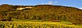
 2022-07-08 Plesse. Wanfried, Hessen IMG 7077 Christoph Braun edit.jpg 8,654 × 5,769; 30.24 MB
-
 2022-10-03 Plesse, Wanfried, Hessen IMG 1252 Christoph Braun edit.jpg 8,688 × 5,792; 41.12 MB
-
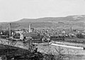
 410 Eschwege Plesse.jpg 777 × 690; 616 KB
-
 449. Wanfrieder Vogelschießen 2017 IMG 5359 edit.jpg 5,616 × 3,744; 11.02 MB
-
 Am Schloßberg (40).jpg 5,970 × 2,941; 6.24 MB
-
 Am Schloßberg (41).jpg 4,248 × 3,142; 5.38 MB
-
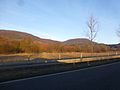 Blick zur Plesse bei Wanfried.jpg 4,320 × 3,240; 2.18 MB
-
-
 Frieda mit Plesse.jpg 9,005 × 5,000; 8.94 MB
-
 Kurfürstenthum Hessen Blatt Wanfried Ausschnitt Plesse.jpg 2,777 × 1,645; 2.57 MB
-
 Naturschutzgebiet Plesse-Konstein im Werra-Meißner-Kreis (2).jpg 5,184 × 3,888; 6.89 MB
-
 OpenTopoMap Topographische Detailkarten 303.png 1,771 × 924; 2.06 MB
-
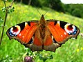 Pfauenauge, Plesse-Konstein.JPG 3,072 × 2,304; 694 KB
-
 Plesse Wanfried 2.2.jpg 3,000 × 725; 874 KB
-
 Plesse Wanfried 2.jpg 3,000 × 725; 1.1 MB
-
 Plesse Wanfried.jpg 5,000 × 597; 1.61 MB
-
 Südeichsfeld 02.jpg 3,648 × 2,736; 4.18 MB
-
 Wanfried Panorama edit.jpg 6,762 × 5,428; 26.11 MB
-
 Wanfried Panorama edit.tif 4,916 × 2,768; 22.66 MB
-
 Zonengrenze an der Keudelskuppe, Thüringen, Deutschland IMG 8592 edit.jpg 5,616 × 3,744; 21.25 MB


.jpg)
.jpg)


.jpg)


