Category:Platane im Frauenkirchhof Grimma
Jump to navigation
Jump to search
| Object location | | View all coordinates using: OpenStreetMap |
|---|
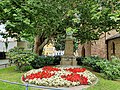
natural monument in Grimma Municipality, Saxony, Germany; Plane tree in the churchyard of the Frauenkirche  | |||||
| Upload media | |||||
| Instance of | |||||
|---|---|---|---|---|---|
| Location | Grimma, Landkreis Leipzig, Saxony, Germany | ||||
| Heritage designation | |||||
 | |||||
Media in category "Platane im Frauenkirchhof Grimma"
The following 11 files are in this category, out of 11 total.
-
 Naturdenkmal. Frauenkirchhof in Grimma, Sachsen 2H1A6998WI.jpg 3,512 × 3,953; 5.01 MB
-
 Naturdenkmal. Frauenkirchhof in Grimma, Sachsen 2H1A7001WI.jpg 3,648 × 5,472; 7.26 MB
-
 Naturdenkmal. Frauenkirchhof in Grimma, Sachsen 2H1A7003WI.jpg 3,648 × 5,472; 6.07 MB
-
 Platane im Frauenkirchhof 01.jpg 3,456 × 4,608; 7.44 MB
-
 Platane im Frauenkirchhof 02.jpg 3,024 × 4,032; 8.6 MB
-
 Platane im Frauenkirchhof 03.jpg 4,032 × 3,024; 8.1 MB
-
 Platane im Frauenkirchhof 04.jpg 3,024 × 4,032; 7.7 MB
-
 Platane im Frauenkirchhof 05.jpg 3,024 × 4,032; 7.54 MB
-
 Platane im Frauenkirchhof 06.jpg 3,024 × 4,032; 5.81 MB
-
 Platane im Frauenkirchhof 07.jpg 3,024 × 4,032; 8.49 MB
-
 Platane im Frauenkirchhof 08.jpg 4,608 × 3,456; 8.38 MB


