Category:Platan u svaté Anny
Jump to navigation
Jump to search
| Object location | | View all coordinates using: OpenStreetMap |
|---|
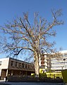
memorable tree in Brno-město District, Czech Republic  | |||||
| Upload media | |||||
| Instance of |
| ||||
|---|---|---|---|---|---|
| Location | Fakultní nemocnice u sv. Anny v Brně, Old Brno, Brno-střed, Brno, Brno-City District, South Moravian Region, Czechia | ||||
| Maintained by | |||||
| Height |
| ||||
 | |||||
Media in category "Platan u svaté Anny"
The following 6 files are in this category, out of 6 total.
-
 Platan u sv. Anny 2.jpg 2,112 × 2,816; 2.79 MB
-
 Platan u svaté Anny, Brno (2).JPG 4,000 × 3,000; 4.62 MB
-
 Platan u svaté Anny, Brno (3).JPG 3,990 × 2,993; 4.38 MB
-
 Platan u svaté Anny, Brno (4).JPG 3,993 × 2,993; 5.09 MB
-
 Platan u svaté Anny, Brno (5).JPG 2,991 × 3,995; 4.44 MB
-
 Platan u svaté Anny, Brno.JPG 2,991 × 3,771; 3.43 MB
.JPG)
.JPG)
.JPG)
.JPG)
