Category:Plantlust ('s-Heer Abtskerke)
Jump to navigation
Jump to search
| Object location | | View all coordinates using: OpenStreetMap |
|---|
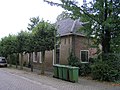
farmhouse in Borsele, Netherlands  | |||||
| Upload media | |||||
| Instance of | |||||
|---|---|---|---|---|---|
| Location | 's-Heer Abtskerke, Q35030737 | ||||
| Street address |
| ||||
| Located on street |
| ||||
| Heritage designation |
| ||||
 | |||||
Nederlands: Boerderij Plaatlust
|
This is a category about rijksmonument number 9976
|
| Address |
|
Media in category "Plantlust ('s-Heer Abtskerke)"
The following 3 files are in this category, out of 3 total.
-
 Aanzicht - 's-Heer Abtskerke - 20105380 - RCE.jpg 1,200 × 808; 234 KB
-
 Aanzicht - 's-Heer Abtskerke - 20105381 - RCE.jpg 1,200 × 809; 295 KB
-
 Abtskerke Kerkring 18.jpg 2,288 × 1,712; 834 KB

