Category:Plane tables
Jump to navigation
Jump to search
device used in surveying and related disciplines to provide a solid and level surface on which to make field drawings, charts and maps  | |||||
| Upload media | |||||
| Subclass of | |||||
|---|---|---|---|---|---|
| Has use |
| ||||
| |||||
Subcategories
This category has the following 2 subcategories, out of 2 total.
G
- Goniographe (6 F)
K
- Kippregel (10 F)
Media in category "Plane tables"
The following 35 files are in this category, out of 35 total.
-

-
 Brockhaus and Efron Encyclopedic Dictionary b37 091-0.jpg 950 × 750; 95 KB
-
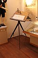 Cvalšiny, muzeum, měřický stůl.jpg 3,456 × 5,184; 6.49 MB
-

-

-

-
 Fotothek df tg 0000239 Geometrie ^ Vermessung ^ Instrument.jpg 800 × 501; 168 KB
-
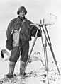 Frank Debenham.jpg 894 × 1,239; 392 KB
-
 Grande Armée - Geographical Engineers.jpg 1,816 × 2,012; 744 KB
-
 Jerome O. Kilmartin, topographer, Flores Guatemala 1923 cropped.jpg 1,318 × 1,779; 1.5 MB
-
 Johnson plane-table Plate XLI WBClark 1898.jpg 858 × 527; 39 KB
-
 Johnson-with-plane-table-and-horsecropped.jpg 279 × 304; 32 KB
-
 Landmåler1.jpg 2,953 × 2,219; 551 KB
-
 Maalebord.jpg 1,566 × 934; 124 KB
-
 Maalebord5.jpg 697 × 701; 97 KB
-
 Meyers b11 s0519 b1.png 558 × 486; 69 KB
-
 Meyers b9 s0746 b1.png 569 × 496; 67 KB
-
 Měřický, topografický stolek a průzor s ukázkou protínání vpřed.png 552 × 343; 52 KB
-
 Noaa theb1713 1.jpg 545 × 478; 140 KB
-
 Plane Table survey.jpg 2,985 × 3,651; 1.5 MB
-
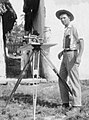
 Plane Table surveying 2014-08-17 12-56.jpg 1,280 × 960; 192 KB
-
 The plane table and its use in surveying (IA planetableitsuse00loverich).pdf 712 × 1,089, 64 pages; 8.65 MB
-
 Russia stamp 2020 № 2679.jpg 1,193 × 1,178; 1.45 MB
-
 Students doing Plane Table Surveying (Zohaib-Mirza).jpg 960 × 960; 161 KB
-
 Surveying. A plane table manual (IA surveyingplaneta00usco).pdf 1,258 × 1,670, 120 pages; 6.46 MB
-
 Table of Surveying, Cyclopaedia, Volume 2.jpg 1,928 × 2,448; 1.66 MB
-
 Theb1700 - Flickr - NOAA Photo Library.jpg 1,380 × 900; 291 KB
-
 Theb1702 - Flickr - NOAA Photo Library.jpg 908 × 1,356; 267 KB
-
 Theb1711 - Flickr - NOAA Photo Library.jpg 1,392 × 904; 342 KB
-
 Theb1714 - Flickr - NOAA Photo Library.jpg 1,392 × 896; 302 KB
-
 Theb1749 - Flickr - NOAA Photo Library.jpg 695 × 447; 166 KB
-

-
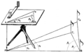
 Traverse plane-table alidades Fig 2 Plate XXXVIII WBClark 1898.jpg 2,002 × 579; 48 KB
-
 A treatise on the plane-table and its use in topographical surveying (IA treatiseonplanet00harr).pdf 1,358 × 1,775, 62 pages; 4.45 MB
-
 US Army Corps of Engineers Map Making, World War I.jpg 1,944 × 1,636; 125 KB
.jpg)


.jpeg)
.jpeg)
.jpeg)


.jpg)


_(14782256895).jpg)