Category:Pingualuit
Jump to navigation
Jump to search
| Object location | | View all coordinates using: OpenStreetMap |
|---|
impact crater in Quebec, Canada .jpg)  | |||||
| Upload media | |||||
| Instance of | |||||
|---|---|---|---|---|---|
| Named after |
| ||||
| Located in protected area | |||||
| Location | Rivière-Koksoak, Kativik Regional Government, Nord-du-Québec, Quebec, Canada | ||||
| Diameter |
| ||||
 | |||||
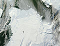
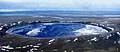
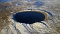
- English: Pingualuit Crater is a meteoric impact crater in the Nunavik region of Quebec, Canada. The body of water filling its depression is called Pingualuk Lake.
- Français : Le Cratère des Pingualuit est un cratère d'impact météorique dans le territoire du Nunavik, Québec, Canada. Le bassin qu'il renferme se nomme Lac Pingualuk.
Media in category "Pingualuit"
The following 10 files are in this category, out of 10 total.
-
 Air photo of Pingualuit Crater.jpg 1,000 × 810; 126 KB
-
 Ice-Free Crater Lakes on Ungava Peninsula.jpg 2,600 × 2,000; 786 KB
-
 Pano Pingualuit Crater LK.jpg 2,081 × 907; 293 KB
-
 Pingualuit aerial 2007 (cropped).jpg 5,442 × 3,063; 3.49 MB
-
 Pingualuit aerial 2007.jpg 6,000 × 4,000; 2.32 MB
-
 Pingualuit Crater - panoramio.jpg 3,648 × 2,736; 1.6 MB
-
 Pingualuit crater LC08 L1TP 020017 20190628 20190706 01 T1.jpg 500 × 375; 52 KB
-
 Pingualuit Crater LK.jpg 2,048 × 1,536; 385 KB
-
 Pingualuit Crater, Nunavik Province, Canada (ASTER).jpg 1,015 × 977; 187 KB
-
 Pingualuit Crater.jpg 500 × 375; 80 KB


.jpg)