Category:Pilgrim's Shelter, Trimingham
Jump to navigation
Jump to search

| Object location | | View all coordinates using: OpenStreetMap |
|---|
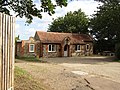
English: The vicar of the parish church in Trimingham, the Reverend Page, along with his gardeners, built the Pilgrim Shelter in 1935. It was to be used as a social club for the men of the village and once completed had a full-sized billiard table and dart board. In recent times the building has been used as Trimingham’s village hall until the completion of a new hall in 2018.
Media in category "Pilgrim's Shelter, Trimingham"
The following 18 files are in this category, out of 18 total.
-
 -2018-12-11 Pilgrim shelter, Trimingham (1).JPG 5,152 × 3,864; 7.75 MB
-
 -2018-12-11 Pilgrim shelter, Trimingham (2).JPG 5,152 × 3,864; 6.73 MB
-
 -2018-12-11 Pilgrim shelter, Trimingham (3).JPG 5,152 × 3,864; 7.52 MB
-
 -2018-12-13 Rear of Pilgrim shelter, Trimingham.JPG 5,152 × 3,864; 6.55 MB
-
 -2019-08-25 Yard sale, Pilgrim shelter, Loop road, Trimingham (1).JPG 5,152 × 3,864; 9.68 MB
-
 -2019-08-25 Yard sale, Pilgrim shelter, Loop road, Trimingham (2).JPG 5,152 × 3,864; 9.17 MB
-
 -2019-11-30 East elevation, Pilgrim shelter, Loop road, Trimingham.JPG 5,152 × 3,864; 11.2 MB
-
 -2020-08-21 Pilgrim's Shelter, Loop road, Trimingham.JPG 5,152 × 3,864; 8.02 MB
-
 -2022-07-09 Pilgrim Shelter sign, Trimingham, Norfolk, England.JPG 5,152 × 3,864; 4.87 MB
-
 -2022-12-11 Pilgrim’s Shelter, Loop Road, Trimingham, Norfolk, England.JPG 5,152 × 3,864; 6.04 MB
-
 -2023-02-01 Pilgrim's Shelter, Trimingham, Norfolk.JPG 5,152 × 3,864; 6.71 MB
-
 -2023-02-01 Rainwater down pipe, Pilgrim's Shelter, Trimingham, Norfolk.JPG 3,864 × 5,152; 5.23 MB
-
 -2023-02-04 Pilgrim’s Shelter, Loop Road, Trimingham, Norfolk, England.JPG 5,152 × 3,864; 7.68 MB
-
 2017-04-26 Pilgrim's Shelter, Loop road, Trimingham.JPG 5,152 × 3,864; 6.34 MB
-
 2017-04-26 Plaque, Pilgrim's Shelter, Loop road, Trimingham.JPG 5,152 × 3,864; 7.59 MB
-
 2018-06-20 Pilgrim's Shelter, Trimingham.JPG 5,152 × 3,864; 7.54 MB
-
 23 North facing elevation, Pilgrims shelter, Loop Road, Trimingham.JPG 5,152 × 3,864; 6.97 MB
-
 Trimingham Village Hall - fundraising - geograph.org.uk - 5019388.jpg 4,896 × 3,672; 6.6 MB
.JPG)
.JPG)
.JPG)

.JPG)
.JPG)


