Category:Pieter Sluyter (cartographer)
Jump to navigation
Jump to search
16th century surveyor in the ancient Holland county | |||||
| Upload media | |||||
| Country of citizenship | |||||
|---|---|---|---|---|---|
| Occupation | |||||
| Sibling |
| ||||
| Work location |
| ||||
| |||||
Media in category "Pieter Sluyter (cartographer)"
The following 13 files are in this category, out of 13 total.
-
-
 Blauwe-sluis (Drimmelen).jpg 500 × 489; 94 KB
-

-
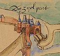
 Costverlorenpoort.jpg 949 × 649; 225 KB
-

-

-
 Koepoort.jpg 845 × 701; 185 KB
-
 Leiden map Sluyter.jpg 13,450 × 5,597; 9.88 MB
-
 Lopsenpoort.jpg 956 × 650; 195 KB
-
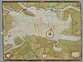
 Nationaal Archief (3382028402).jpg 2,000 × 1,417; 797 KB
-
 NL-HaNA 4.VTH 1895A 0001-00013000472-klein.jpg 1,327 × 999; 178 KB
-
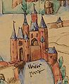 Witte Poort.jpg 767 × 941; 255 KB
-
 Zijlpoort.jpg 897 × 837; 233 KB
_Nationaal_Archief_collectie_Hingman.jpg)
.jpg)


_T_Hooge_Heemraedschap_van_Delflant_met_alle_de_steden,_dorpen,_ambachten,_litmaten,_polders,_blocken,_gehugten,_buerten,_hofsteden,_woningen,_boomgaerden,_t,_RP-P-AO-11-7-14.jpg)


.jpg)


