Category:Photographs by the United States Forest Service Northwest Division
Jump to navigation
Jump to search
U.S. Forest Service- Pacific Northwest Region (photos · photo sets)
English: "by" in this category name should be taken loosely: their Flickr account often includes public domain images by photographers who were not USFS employees. E.g. a lot of old postcards.
Media in category "Photographs by the United States Forest Service Northwest Division"
The following 200 files are in this category, out of 5,621 total.
(previous page) (next page)-
 -017 McKenzie State Fish Hatchery (22039621854).jpg 2,978 × 1,880; 2.69 MB
-
 -09 Martin Rapids (22041276413).jpg 2,977 × 1,800; 2.35 MB
-
 -1 At the McKenzie Fish Hatchery (22474478500).jpg 894 × 1,442; 568 KB
-
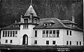
 -10 Belknap Springs Hotel, OR 1949 (22474467000).jpg 2,930 × 1,803; 3.11 MB
-
 -103 Coconut Tree, Rockaway, Ore. (22106962573).jpg 3,047 × 1,899; 2.72 MB
-
 -110 Belknap Springs Hotel (22039610214).jpg 2,898 × 1,797; 3.14 MB
-
 -12 Public School Marcola, Ore. (22039636974).jpg 3,283 × 2,019; 3.38 MB
-
 -1920 Hood Canal & Olympic Mts. 1941 (22730414186).jpg 3,080 × 1,876; 2.09 MB
-
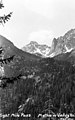
 -23 Upper Methow Valley, Wash (22134127554).jpg 3,021 × 1,757; 1.99 MB
-
 -23-a One Days Catch on the Trask River, OR (22739293781).jpg 3,101 × 1,909; 3.64 MB
-
 -25 Eight Mile Pass. Methow Valley, Wn (22756888785).jpg 1,837 × 2,949; 2.38 MB
-
 -260 'Lake Odell' near Summit Lodge - New Willamette Highway (21971958414).jpg 2,905 × 1,780; 1.96 MB
-
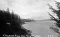 -29 Tillamook Bay near Bay City Ore. (22540183400).jpg 3,055 × 1,900; 2.08 MB
-
 -32 USFS Buildings at Winthrop, Wash (22768101891).jpg 3,028 × 1,775; 2.03 MB
-
 -3310 Olympic NF on the Road to Lake Quinault, WA (22756469855).jpg 1,959 × 3,130; 3.38 MB
-
 -42 Nehalem River, Ore. (22540182640).jpg 3,192 × 2,030; 2.79 MB
-
 -63 Garibaldi Beach with RR Tracks (22106963653).jpg 3,145 × 2,047; 3.18 MB
-
 -75 Falls on the Nehalem, OR (22728098675).jpg 2,017 × 3,175; 2.88 MB
-
 0013 p1-53 Shasta Costa Ranger Station. Siskiyou N.F., July 1922 (22125451579).jpg 5,862 × 4,644; 3.58 MB
-
 0015 p1-65 Eden Valley RS Feb 28, 1908 (22124267550).jpg 2,242 × 1,559; 486 KB
-
 002 Gero Mitschelen (22298575242).jpg 662 × 556; 57 KB
-
 005 Recreation fishing pier Timothy Lake Mt Hood National Forest (36379636023).jpg 5,332 × 3,568; 2.17 MB
-
 0054 p4-67 Iron Mtn. LO Agness RD 1944 (22286229256).jpg 1,890 × 3,036; 405 KB
-
 0055 p4-72 Fish Hook LO Agness RD 1944 (22125435779).jpg 1,846 × 3,050; 460 KB
-
 0057 p4-78 Wildhorse LO Agness RD 1944 (22124260280).jpg 1,730 × 3,150; 356 KB
-
 007 Bodie Mountain Lookout 2 (21690523903).jpg 1,033 × 1,672; 525 KB
-
 009 Strawberry Mt Lookout 6-19-1946 (22124742569).jpg 562 × 728; 190 KB
-

-
 010 Fire camp timekeepers,Horseshoe Bend Fire 1939 Siskiyou NF (36209286455).jpg 5,144 × 3,540; 10.76 MB
-
 010 Mt Annie Lookout 1 (22123568540).jpg 1,100 × 1,655; 711 KB
-
 011 Mt Annie Lookout 2 (22123567980).jpg 1,075 × 1,697; 635 KB
-
 014126A Ranger Posting Sign, SisNF, OR 1913 (21417922783).jpg 2,240 × 2,840; 4.14 MB
-
 014790A Sand Pass, Wallowa NF, OR 1911 (22026718942).jpg 2,245 × 1,423; 2.04 MB
-

-
 021 Forest Service officer views Entiat River, Wenatchee NF 1960's (36209278545).jpg 5,312 × 3,588; 13.67 MB
-
 024717A Bear Camp LOT, SisNF, OR 1915 (21417922373).jpg 1,160 × 873; 678 KB
-

-
 033492A Railroad Creek Valley, Okanogan NF, WA 1916 (21418428963).jpg 2,408 × 1,880; 3.04 MB
-
 038 two women skiers, 1930's (36209271335).jpg 5,356 × 3,600; 9.15 MB
-
 04 lost lake 1924 (22123412678).jpg 608 × 412; 19 KB
-
 0438 Trail Crew 1910 Fires in ID (22773925871).jpg 1,424 × 1,134; 615 KB
-
 044972A McKenzie Highway near Blue River, Cascade NF, OR (22026718622).jpg 2,848 × 1,848; 3.26 MB
-
 049327 Railroad Camp, Santiam Pass, Santiam NF, OR 1920 (22039065715).jpg 1,912 × 1,249; 1.34 MB
-
 049574A Fireman Homesteader Cabin, Umatilla NF, OR (21851548158).jpg 1,554 × 874; 285 KB
-
 05 lost lake 1924 (22123412648).jpg 608 × 412; 22 KB
-
 07 ruby wiltz cedar ck camp 1929 (21689693863).jpg 479 × 824; 36 KB
-
 077974 Ranger & Horses, Davis Cr Canyon, Wallowa NF, OR 1908 (22012876246).jpg 2,448 × 1,864; 2.99 MB
-
 077984 JR Carper, FS Hunter & Trapper, W-WNF, OR (21852161449).jpg 2,447 × 1,864; 2.7 MB
-
 077986 JR Carper, FS Hunter, OR, W-WNF (22026717622).jpg 2,471 × 1,824; 3.02 MB
-
 083 MSH institute slide show (21852902459).jpg 790 × 564; 357 KB
-
 084 MSH institute slide show (22049727131).jpg 1,200 × 797; 150 KB
-
 086 MSH institute slide show030 (21418657783).jpg 1,066 × 800; 300 KB
-
 087 MSH institute slide show024 (21851634630).jpg 1,200 × 797; 250 KB
-
 088 MSH institute slide show025 (22039807685).jpg 1,200 × 797; 241 KB
-
 089 MSH05 dome from sugarbowl camera (21852902329).jpg 1,200 × 900; 358 KB
-
 090 MSH institute slide show026 (21418657673).jpg 1,066 × 800; 189 KB
-
 091 MSH institute slide show027 (21852902259).jpg 1,066 × 800; 202 KB
-
 092 MSH institute slide show028 (22049726911).jpg 1,066 × 800; 158 KB
-
 093 MSH05 aerial st helens with plume from SW 03-08-05 resize (21416993134).jpg 1,200 × 797; 260 KB
-
 094 MSH05 plume from CVO office 03-08-05 resize (22049726871).jpg 1,141 × 726; 409 KB
-
 095 MSH04 new dome from east 11-04-04 resize (21416993044).jpg 1,200 × 797; 287 KB
-
 095547 Road & Loading Donkey Engines, Oregon NF, OR 1911 (22012876156).jpg 2,816 × 2,016; 2.98 MB
-
 096 MSH05 aerial st helens from SE 02-03-05 resize (21851943838).jpg 1,200 × 797; 273 KB
-
 097 Cascades of the Columbia and Government Locks by C&D (22488574792).jpg 6,118 × 2,067; 5.47 MB
-
 097 MSH institute slide show029 (21851634450).jpg 1,066 × 800; 245 KB
-
 098 MSH05 crater new dome from NW 02-22-05 resize (21851943828).jpg 1,200 × 797; 343 KB
-
 099 MSH05 new dome from brutus 03-11-05 resize (22013614986).jpg 1,200 × 897; 418 KB
-
 1 Log Jam, Nehalem River, Tillamook, Ore (22106964533).jpg 3,042 × 1,865; 2.29 MB
-

-
 10-11 Umpqua Coast Guard Station, OR (22105353734).jpg 3,022 × 1,821; 1.93 MB
-
 100 Bull Run area after wildfire (36074466221).jpg 5,396 × 3,612; 7.61 MB
-
 100 MSH05 new dome glacier uplift from east 02-22-05 resize (21418657463).jpg 1,200 × 797; 367 KB
-
 101 MSH05 spine from NE 07-26-05 resize (21852902029).jpg 1,200 × 797; 405 KB
-
 1011First Butte Lookout Tower, Okanogan National Forest, WA 7-15-1952 (22573663230).jpg 2,120 × 2,833; 978 KB
-
 102 MSH05 sharp point on spine 07-26-05 resize (22027453942).jpg 1,200 × 797; 378 KB
-
 102 Sightseeing along the Mt Hood Loop Hwy 1920's (36074464641).jpg 5,356 × 3,572; 9.92 MB
-
 102B MSH institute slide show148 (22039807235).jpg 1,200 × 797; 196 KB
-
 103 climb to MSH summit (21418657343).jpg 1,632 × 1,232; 440 KB
-
 104 First car to reach Government Camp (36074463291).jpg 5,360 × 3,596; 7.57 MB
-
 104 Y.M.C.A. Soldiers Band & Song Meeting Newport (21419238853).jpg 2,800 × 2,224; 2.88 MB
-
 105 Barlow Road Mt Hood 1900's (36042516372).jpg 5,324 × 3,588; 8.22 MB
-
 105 IMG 2549 resize (21418657293).jpg 1,200 × 800; 452 KB
-
 106 IMG 2543 resize (22027453842).jpg 1,200 × 800; 421 KB
-
 10691A Seed Extracting Plant at Wyeth, Oregon NF, OR c1905 (21420229084).jpg 1,976 × 1,214; 324 KB
-
 107 IMG 2544 resize (22013614756).jpg 1,200 × 800; 516 KB
-
 10706A Collecting Tree Seeds at Wyeth, OR NF, OR c1905 (22016857846).jpg 2,487 × 3,829; 3.97 MB
-
 10714A Cleaning Tree Seeds, Wyeth, OR NF c1905 (22016856576).jpg 3,788 × 2,502; 3.26 MB
-
 108 IMG 2551 resize (21852901739).jpg 1,200 × 800; 502 KB
-
 108 Mt Hood Nat'l Forest, bottom of Magic Mile lift Timberline Lodge (36074460961).jpg 3,604 × 5,324; 11.12 MB
-
 1083 First Butte LOT, Okanogan NF, WA 7-15-1952 (22140698343).jpg 2,785 × 2,125; 1,000 KB
-
 109 First car o Mt Hood Loop Highway (36042513872).jpg 5,324 × 3,596; 7.63 MB
-
 109 IMG 2580 resize (22013614636).jpg 1,200 × 808; 459 KB
-
 109 Snoqualmie Falls, 268 ft., WA - Ellis (22743898192).jpg 1,841 × 2,935; 1.81 MB
-
 109 Winter Scene, Snoqulamie Pass, WA - Ellis (22569520290).jpg 3,081 × 1,815; 2.55 MB
-
 1090 Trapper Setting Beaver Trap, Ochoco NF - Ernest Lindsay (22039424695).jpg 2,853 × 1,745; 3.47 MB
-
 1090 Trapper Setting Beaver Trap, Ochoco NF - Ernest Lindsay (22731784986).jpg 2,853 × 1,745; 3.47 MB
-
 11 cutting poles on fs land 1923 (21689013814).jpg 802 × 463; 259 KB
-
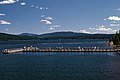
 11-509 Spillway Gates Bonneville Dam (22502015155).jpg 2,901 × 1,750; 2.12 MB
-
 11-647 Mt. Hood, Oregon (21420254074).jpg 2,994 × 1,736; 1.9 MB
-
 11-825 Pioneer Woman's Grave, Mt. Hood NF, OR (22030721042).jpg 2,945 × 1,770; 2.33 MB
-
 110 IMG 259A resize (22039806855).jpg 1,200 × 800; 292 KB
-
 111 IMG 2572 resize (22013614616).jpg 1,200 × 800; 263 KB
-
 112 IMG 2576 resize (22049726341).jpg 1,200 × 800; 448 KB
-

-
 113 Massive timber blowdown outside heat blast zone, Mt St Helens eruption (36042509362).jpg 5,324 × 3,604; 17.87 MB
-
 113 Sunset on the Puget Sound, Wash. (22756469445).jpg 1,893 × 3,046; 2.14 MB
-
 114 IMG 2589 resize (22027453502).jpg 1,200 × 800; 355 KB
-
 114A IMG 2582 resize (21852901569).jpg 1,200 × 800; 213 KB
-
 115 climb to MSH summit (22039806735).jpg 1,632 × 1,232; 474 KB
-

-
 116 climb to MSH summit (21852901499).jpg 1,632 × 1,232; 458 KB
-
 116 Track Laying North of Yaquina (21852215130).jpg 2,800 × 2,272; 3.46 MB
-
 116- On the upper Quinault River trail. 1927 (26232088861).jpg 2,416 × 3,824; 994 KB
-
 117 Joint USGS and Forest Service press conference May 18, 1980 (36168091886).jpg 5,328 × 3,592; 18.49 MB
-
 117 MSH institute slide show136 (22039806605).jpg 1,200 × 797; 374 KB
-
 117 Track Laying North of Yaquina (22014198506).jpg 2,816 × 2,216; 2.6 MB
-
 118 institute slide show137 (21416992174).jpg 1,200 × 797; 416 KB
-
 118 Sportsman and Tourist Map of Olympic Peninsula, Washington (22133703404).jpg 3,235 × 2,047; 5.06 MB
-
 119 MSH institute slide show139 (22027453332).jpg 1,200 × 797; 398 KB
-
 11903A LO with Heliograph CA 1912 (22762702845).jpg 2,820 × 1,884; 510 KB
-
 12 Bonneville Dam by C&D (22513098491).jpg 2,984 × 1,827; 2.14 MB
-
 120 MSH institute slide show138 (21852901479).jpg 1,200 × 797; 422 KB
-
 121 MSH institute slide show140 resize (21851942968).jpg 1,069 × 800; 449 KB
-
 122 MSH institute slide show141 (22049725981).jpg 1,200 × 797; 437 KB
-
 122 Mt. Olympus from High Divide (22730447756).jpg 3,033 × 1,838; 2.32 MB
-
 1221 rabbit hunters (22769012991).jpg 974 × 456; 73 KB
-
 123 MSH institute slide show142 (22027453192).jpg 1,066 × 800; 402 KB
-
 124 MSH institute slide show143 (21852901249).jpg 1,066 × 800; 328 KB
-
 124 RR Trestle (22050309261).jpg 2,840 × 2,240; 2.81 MB
-
 12427A Smith Prairie RS, Santiam NF, OR 1912 (22039422615).jpg 4,039 × 5,687; 8.95 MB
-
 12433A Ranger Tree Phone Cascade NF (22762702255).jpg 1,064 × 1,488; 222 KB
-
 12433A Ranger Tree Phone Santiam NF OR 1912 (22027068762).jpg 1,064 × 1,488; 1.05 MB
-
 125 MSH and dome resize (21851633550).jpg 1,200 × 783; 365 KB
-

-
 1261 Rooster Rock 285 Feet by C&D (22314225558).jpg 3,201 × 1,981; 2.54 MB
-
 127 IMG 2608 resize (21851942838).jpg 1,200 × 800; 367 KB
-
 127 Massive deposit of ash near Mt St Helens volcano (35373446554).jpg 5,312 × 3,620; 15.25 MB
-
 127 Rosario Beach, Wn., c1920 - Clyde Banks (22767680641).jpg 3,052 × 1,835; 2.14 MB
-
 127 RR Trestle (22040384285).jpg 2,240 × 2,800; 2.06 MB
-
 1276 Fire Fighters Edson Fire, So Oregon 1936 - Ernest Lindsey (21851250290).jpg 3,658 × 2,232; 3.42 MB
-
 128 Heat blast zone Coldwater Lake, Mt St Helens (36042493442).jpg 5,324 × 3,624; 16.27 MB
-
 128 MSH institute slide show015 (21851633350).jpg 1,200 × 796; 349 KB
-
 128 RR Trestle (22014198316).jpg 2,792 × 2,200; 2.29 MB
-
 1286 Salmon Trap Fish Wheel, Columbia River (22315096869).jpg 3,208 × 2,005; 4.75 MB
-
 129 Devastation after May 18th eruption Mt St Helens (35373444594).jpg 5,324 × 3,596; 15.71 MB
-
 129 MSH institute slide show016 (21852901089).jpg 1,200 × 797; 471 KB
-
 129 RR Trestle with Hotel (21419238513).jpg 2,784 × 2,216; 2.05 MB
-
 13 De Lake, Oregon (22106986853).jpg 3,011 × 1,881; 2.27 MB
-
 130 Blowndown timber and ash covered forest road (36042492432).jpg 5,324 × 3,604; 14.62 MB
-
 130 MSH steaming000 resize (22013613956).jpg 1,200 × 797; 319 KB
-
 131 Image111 resize (22049725831).jpg 1,024 × 680; 392 KB
-
 131 Soldiers Mess Camp 7-H Molock Creek (21417566954).jpg 2,824 × 2,216; 2.08 MB
-
 132 Looking Down at Camp 7-H, Molock Creek (22014198096).jpg 2,824 × 2,216; 3.43 MB
-
 132 MSH at sunset001 resize (21418656513).jpg 1,200 × 797; 361 KB
-
 132 Olympic Mountains from Hood Canal - Wash - Ellis (22568549800).jpg 2,980 × 1,847; 2.43 MB
-
 132 Road Around Hug Point, Cannon Beach, Ore. (22739368211).jpg 2,023 × 3,170; 2.34 MB
-
 132 Siletz River, OR (22105403464).jpg 3,265 × 2,055; 3.72 MB
-
 133 MSH institute slide show145 (21851633200).jpg 1,200 × 814; 383 KB
-
 134 MSH institute slide show033 (21851633170).jpg 1,024 × 680; 483 KB
-
 134 Mt Hood National Forest, historic floods, landslides (35816032450).jpg 5,356 × 3,548; 15.78 MB
-
 134 Pre eruption Spirit lake beach and dock 1978 (36042487402).jpg 5,324 × 3,608; 15.25 MB
-
 134-S Spouting Horn, Depoe Bay, Ore. (22728174385).jpg 3,014 × 1,819; 1.26 MB
-
 135 Grading Right-of-Way, Camp 7-P, East of Otter Rock (22050308921).jpg 2,816 × 2,232; 3.1 MB
-
 135 MSH institute slide show034 (22049725641).jpg 1,024 × 680; 262 KB
-
 1359 French Butte LOH, GPNF, WA 7-1956 (22140602333).jpg 2,773 × 2,113; 837 KB
-
 136 MSH institute slide show154 (21416991624).jpg 1,175 × 800; 220 KB
-
 136 Pre-eruption Spirit Lake, Mt St Helens (35816031660).jpg 5,324 × 3,556; 16.23 MB
-
 136 Siuslaw Bridge, OCH, OR (22540258370).jpg 3,019 × 1,905; 1.86 MB
-
 1364 Ellis Homestead 1910 (22744255352).jpg 1,276 × 1,214; 217 KB
-
 137 Log Culvert to be Covered, Camp 7-P, East of Otter Rock (21417566794).jpg 2,808 × 2,200; 3.43 MB
-
 137 MSH institute slide show150 (22039805985).jpg 1,200 × 797; 130 KB
-
 137 Pre-eruption Mt St Helens (35816030710).jpg 5,324 × 3,556; 19.17 MB
-
 138 MSH institute slide show036 (21852900859).jpg 1,200 × 797; 684 KB
-
 138 Sawing Bridge and Camp Timbers, Camp 7-I, Otter Rock (22028035792).jpg 2,816 × 2,224; 2.84 MB
-
 139 Mill Yard and Teams, Camp 7-I, Otter Rock (21417566364).jpg 2,813 × 2,205; 2.83 MB
-
 139 MSH institute slide show035 (22027452732).jpg 1,200 × 797; 241 KB
-
 14-978 Cape Creek Bridge & Heceta LH Keepers House, OR (22714556912).jpg 3,046 × 1,847; 2.3 MB
-
 140 MSH institute slide show153 (21418656173).jpg 1,200 × 800; 155 KB
-
 140 Plank Road (22040383635).jpg 2,776 × 2,200; 2.73 MB
-
 14126A Ranger Posting Sign, Siskiyou NF, OR 1913 (21418274693).jpg 2,240 × 2,840; 4.14 MB
-
 143 Pile Driver, Camp 5-A South Beach (21853484989).jpg 2,232 × 2,728; 2.28 MB
-
 144 Ascending Eliot Glacier, Mt. Hood, OR (22016869486).jpg 2,959 × 1,789; 1.68 MB
-
 144 Cut and Tracks Near South Beach Terminal Trestle (21853484609).jpg 2,255 × 2,712; 3.12 MB
-
 145 Material Yards, Camp 5-A, South Beach (22040383255).jpg 2,744 × 2,240; 3.32 MB
-
 146 Devils Peak Lookout, Mt Hood Nat'l Forest (36042483142).jpg 5,336 × 3,592; 8.54 MB
-
 147 Raising Track on Curve, Camp 5-A, South Beach (21853484589).jpg 2,471 × 2,175; 2.62 MB
-
 148 Reinforcing Track on Curve, Camp 5-A, South Beach (21852522958).jpg 2,799 × 2,215; 3.06 MB
-
 149 Albert K Wiesendanger with girlfriend, Hemlock RS depot 1916 (35816025120).jpg 5,348 × 3,552; 6.93 MB
-
 149 Curve Near Camp 5-A, South Beach (21419237113).jpg 2,816 × 2,240; 3.37 MB
-
 14987A Heliograph in Use 1913 (22736702676).jpg 987 × 1,267; 897 KB
-
 14989A Heliograph in Use 1 (22141587183).jpg 1,011 × 1,230; 943 KB
-
 14994A Heliograph in Use 1913 (22139947904).jpg 1,066 × 1,326; 1.47 MB
-
 15-038 Siuslaw River Bridge at Florence, OCH, OR (22739316641).jpg 3,022 × 1,909; 2.45 MB
-
 15-041 Coos Bay Bridge, Oregon (22714556602).jpg 3,029 × 1,866; 2.34 MB
-
 15-042 Coos Bay Bridge, 5337 ft Long, Ore. (22739318091).jpg 3,026 × 1,863; 2.75 MB
-
 15-082 Group of 411 Climbers, Summit Mt. Hood, OR (21856174959).jpg 1,891 × 3,025; 2.72 MB
-
 15-328 Yaquina Bay Bridge, OCH, OR (22106987573).jpg 3,019 × 1,845; 2.12 MB
-
 15-405 Heceta Head Light House - OCH 101 (22540238250).jpg 1,831 × 3,007; 1.83 MB
-
 15-438 Aerial View of Bonneville Dam Area by Brubaker (22488592692).jpg 2,965 × 1,834; 2.51 MB
-
 15-570 Heceta Head Lighthouse and Tunnel - OCH (22105385704).jpg 3,003 × 1,871; 2.32 MB
.jpg)
.jpg)
.jpg)
.jpg)
.jpg)
.jpg)
.jpg)
.jpg)
.jpg)
.jpg)
.jpg)
.jpg)
.jpg)
.jpg)
.jpg)
.jpg)
.jpg)
.jpg)
.jpg)
.jpg)
.jpg)
.jpg)
.jpg)
.jpg)
.jpg)
.jpg)
.jpg)
.jpg)
.jpg)
.jpg)
.jpg)
.jpg)
.jpg)
.jpg)
.jpg)
.jpg)
.jpg)
.jpg)
.jpg)
.jpg)
.jpg)
.jpg)
.jpg)
.jpg)
.jpg)
.jpg)
.jpg)
.jpg)
.jpg)
.jpg)
.jpg)
.jpg)
.jpg)
.jpg)
.jpg)
.jpg)
.jpg)
.jpg)
.jpg)
.jpg)
.jpg)
.jpg)
.jpg)
.jpg)
.jpg)
.jpg)
.jpg)
.jpg)
.jpg)
.jpg)
.jpg)
.jpg)
.jpg)
.jpg)
.jpg)
.jpg)
.jpg)
.jpg)
.jpg)
.jpg)
.jpg)
.jpg)
.jpg)
.jpg)
.jpg)
.jpg)
.jpg)
.jpg)
.jpg)
.jpg)
.jpg)
.jpg)
.jpg)
.jpg)
.jpg)
.jpg)
.jpg)
.jpg)
.jpg)
.jpg)
.jpg)
.jpg)
.jpg)
.jpg)
.jpg)
.jpg)
.jpg)
.jpg)
.jpg)
.jpg)
.jpg)
.jpg)
.jpg)
.jpg)
.jpg)
.jpg)
.jpg)
.jpg)
.jpg)
.jpg)
.jpg)
.jpg)
.jpg)
.jpg)
.jpg)
.jpg)
.jpg)
.jpg)
.jpg)
.jpg)
.jpg)
.jpg)
.jpg)
.jpg)
.jpg)
.jpg)
.jpg)
.jpg)
.jpg)
.jpg)
.jpg)
.jpg)
.jpg)
.jpg)
.jpg)
.jpg)
.jpg)
.jpg)
.jpg)
.jpg)
.jpg)
.jpg)
.jpg)
.jpg)
.jpg)
.jpg)
.jpg)
.jpg)
.jpg)
.jpg)
.jpg)
.jpg)
.jpg)
.jpg)
.jpg)
.jpg)
.jpg)
.jpg)
.jpg)
.jpg)
.jpg)
.jpg)
.jpg)
.jpg)
.jpg)
.jpg)
.jpg)
.jpg)
.jpg)
.jpg)
.jpg)
.jpg)
.jpg)
.jpg)
.jpg)
.jpg)
.jpg)
.jpg)
.jpg)
.jpg)
.jpg)
.jpg)
.jpg)
.jpg)
.jpg)
.jpg)
.jpg)
.jpg)
.jpg)
.jpg)