Category:Photographs by Aubrey Dale
Jump to navigation
Jump to search

English: Photographs by Aubrey Dale.
Media in category "Photographs by Aubrey Dale"
The following 200 files are in this category, out of 822 total.
(previous page) (next page)-
 "Battered Bull" at Bangor - geograph.org.uk - 197143.jpg 640 × 426; 103 KB
-
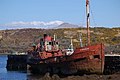 "Pibroch" at Letterfrack - geograph.org.uk - 181176.jpg 640 × 426; 139 KB
-
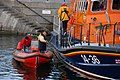 "Saxon" to the rescue - geograph.org.uk - 226804.jpg 640 × 426; 124 KB
-
 "Stop" sign, Millbay Road, Islandmagee - geograph.org.uk - 173888.jpg 640 × 426; 188 KB
-
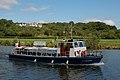 "The Lady Sandel" on the Bann (1) - geograph.org.uk - 220953.jpg 640 × 426; 142 KB
-
 "The Lady Sandel" on the Bann (2) - geograph.org.uk - 220961.jpg 640 × 426; 142 KB
-
 "The Snake", Larne - geograph.org.uk - 244879.jpg 640 × 426; 133 KB
-
 2-1 at Ballynaloob - geograph.org.uk - 221046.jpg 640 × 426; 116 KB
-
 719638 d5e5ba00.jpg 640 × 444; 69 KB
-
 A crafty owl in Bangor - geograph.org.uk - 218301.jpg 640 × 426; 114 KB
-
 A matter of Minor importance (3) - geograph.org.uk - 415919.jpg 640 × 426; 145 KB
-
 A text message for motorists - geograph.org.uk - 217888.jpg 640 × 426; 154 KB
-
 A Water Witch on the Bann (1) - geograph.org.uk - 193937.jpg 640 × 426; 171 KB
-
 A Water Witch on the Bann (2) - geograph.org.uk - 193944.jpg 640 × 426; 152 KB
-
 A wet night on the North Pier - geograph.org.uk - 221458.jpg 640 × 426; 131 KB
-
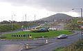 A1 Cloghogue Roundabout.jpg 640 × 399; 49 KB
-
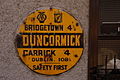 AA-Duncormack.jpg 640 × 426; 152 KB
-
 Abandoned (?) vans, Belfast - geograph.org.uk - 1236572.jpg 640 × 337; 71 KB
-
 Abandoned van, Belfast (2) - geograph.org.uk - 1312851.jpg 640 × 427; 103 KB
-
 Abandoned van, Belfast - geograph.org.uk - 1249035.jpg 640 × 380; 65 KB
-
 Abandoned vans, Belfast (2) - geograph.org.uk - 1254633.jpg 640 × 323; 70 KB
-
 Abandoned vans, Belfast (3) - geograph.org.uk - 1254684.jpg 640 × 353; 38 KB
-
 Abandoned vans, Belfast (4) - geograph.org.uk - 1260132.jpg 612 × 424; 93 KB
-
 Abandoned vans, Belfast (5) - geograph.org.uk - 1266418.jpg 640 × 368; 84 KB
-
 Abandoned vans, Belfast (6) - geograph.org.uk - 1283894.jpg 640 × 361; 75 KB
-
 Abandoned vans, Belfast (7) - geograph.org.uk - 1296835.jpg 640 × 405; 81 KB
-
 Abandoned vans, Belfast (8) - geograph.org.uk - 1323594.jpg 639 × 450; 106 KB
-
 Abandoned vans, Belfast (9) - geograph.org.uk - 1343540.jpg 640 × 372; 94 KB
-
 Above Glenoe waterfall - geograph.org.uk - 212098.jpg 640 × 426; 186 KB
-
 Adrossan(1).jpg 640 × 402; 76 KB
-
 Adrossan(2).jpg 640 × 396; 58 KB
-
 Ageing trains, Whitehead (1) - geograph.org.uk - 1323468.jpg 640 × 379; 68 KB
-
 Ageing trains, Whitehead (2) - geograph.org.uk - 1323485.jpg 640 × 415; 98 KB
-
 Agivey Bann Bridge - geograph.org.uk - 164860.jpg 640 × 426; 118 KB
-
 Altnahinch.jpg 640 × 404; 92 KB
-
 Anglers at Carnroe, River Bann - geograph.org.uk - 235041.jpg 640 × 426; 155 KB
-
 Annalong harbour - geograph.org.uk - 241419.jpg 640 × 426; 121 KB
-
 Approaching Ballywhiskin - geograph.org.uk - 227541.jpg 640 × 426; 133 KB
-
 Approaching Carnalea station - geograph.org.uk - 221601.jpg 640 × 426; 168 KB
-
 Approaching Downshire station - geograph.org.uk - 233765.jpg 640 × 426; 119 KB
-
 Approaching Larne Town station - geograph.org.uk - 244830.jpg 640 × 426; 122 KB
-
 Approaching Marino station - geograph.org.uk - 247544.jpg 640 × 426; 171 KB
-
 Approaching Seahill station - geograph.org.uk - 243422.jpg 640 × 426; 103 KB
-
 Approaching the Boyne Bridge, Bangor - geograph.org.uk - 240415.jpg 640 × 426; 160 KB
-
 Approaching the Six Road Ends - geograph.org.uk - 214843.jpg 560 × 420; 105 KB
-
 Ardglass harbour - geograph.org.uk - 203722.jpg 640 × 426; 147 KB
-
 Arklow harbour - geograph.org.uk - 171379.jpg 640 × 426; 125 KB
-
 Arrival of the "Emerald Gratia" - geograph.org.uk - 206115.jpg 640 × 426; 123 KB
-
 Arrival of the "Havilah" - geograph.org.uk - 235373.jpg 640 × 426; 152 KB
-
 Arthurstown quay - geograph.org.uk - 202390.jpg 640 × 426; 139 KB
-
 At anchor off Bangor (1) - geograph.org.uk - 238319.jpg 640 × 426; 106 KB
-
 Audley's Castle, through trees.jpg 640 × 426; 169 KB
-
 Ballast train 111 at Carrickfergus railway station in 2009.jpg 640 × 367; 75 KB
-
 Ballast train at Magheramorne - geograph.org.uk - 1034076.jpg 640 × 403; 111 KB
-
 Ballast train, Crumlin - geograph.org.uk - 1444231.jpg 640 × 413; 73 KB
-
 Ballievey Road, Banbridge - geograph.org.uk - 171985.jpg 640 × 426; 192 KB
-
 Ballycarry station, 2009 (5) - geograph.org.uk - 1419753.jpg 640 × 395; 87 KB
-
 Ballycrochan Road, Bangor (1) - geograph.org.uk - 203688.jpg 640 × 426; 148 KB
-
 Ballycrochan Road, Bangor (2) - geograph.org.uk - 203694.jpg 640 × 426; 139 KB
-
 Ballycrochan Road, Bangor (3) - geograph.org.uk - 203701.jpg 640 × 426; 168 KB
-
 Ballygally Head, Antrim coast road - geograph.org.uk - 212146.jpg 640 × 426; 130 KB
-
 Ballygrot rath near Helen's Bay - geograph.org.uk - 241221.jpg 640 × 426; 163 KB
-
 Ballyhack harbour - geograph.org.uk - 202941.jpg 640 × 426; 153 KB
-
 Ballyhone Road, Magheramorne (1) - geograph.org.uk - 173219.jpg 640 × 426; 191 KB
-
 Ballymacormick Road, Bangor - geograph.org.uk - 204267.jpg 640 × 426; 162 KB
-
 Ballymacscanlan Bay, Co Louth - geograph.org.uk - 224561.jpg 640 × 426; 131 KB
-
 Ballymoney Road, Ballygrainey - geograph.org.uk - 218272.jpg 640 × 426; 127 KB
-
 Ballynoe Road near Killough - geograph.org.uk - 203873.jpg 640 × 426; 161 KB
-
 Ballysallagh forest, Craigantlet - geograph.org.uk - 221697.jpg 640 × 426; 157 KB
-
 Ballysallagh Road near Bangor - geograph.org.uk - 207341.jpg 640 × 426; 126 KB
-
 Ballytober Road, Islandmagee - geograph.org.uk - 173785.jpg 640 × 426; 165 KB
-
 Balmoral railway station in 2007.jpg 640 × 380; 85 KB
-
 Banbridge bypass, Belfast-Dublin road (1) - geograph.org.uk - 232216.jpg 640 × 426; 138 KB
-
 Banbridge bypass, Belfast-Dublin road (2) - geograph.org.uk - 232228.jpg 640 × 426; 148 KB
-
 The Bangor sundial - geograph.org.uk - 214906.jpg 640 × 426; 141 KB
-
 Bangor lifeboat (1) - geograph.org.uk - 202871.jpg 640 × 426; 140 KB
-
 Bangor marina (1) - geograph.org.uk - 189749.jpg 640 × 426; 161 KB
-
 Bangor marina (2) - geograph.org.uk - 189753.jpg 640 × 426; 162 KB
-
 Bangor railway and bus station - geograph.org.uk - 225290.jpg 640 × 426; 133 KB
-
 Bangor Road, Groomsport (1) - geograph.org.uk - 191411.jpg 640 × 426; 165 KB
-
 Bangor Road, Groomsport (2) - geograph.org.uk - 191414.jpg 640 × 426; 142 KB
-
 Bangor Road, Groomsport (3) - geograph.org.uk - 191419.jpg 640 × 426; 124 KB
-
 Bangor Town Hall (detail) - geograph.org.uk - 214896.jpg 640 × 426; 122 KB
-
 Bangor Town Hall - geograph.org.uk - 214892.jpg 640 × 426; 134 KB
-

-

-
-
 Barn railway station in 1997.jpg 640 × 376; 121 KB
-
 Before the Royal Hotel, Bangor - geograph.org.uk - 227767.jpg 640 × 426; 111 KB
-

-
 Belfast - Dublin road near Newry (1) - geograph.org.uk - 224577.jpg 640 × 426; 134 KB
-
 Belfast - Dublin road near Newry (2) - geograph.org.uk - 234439.jpg 640 × 426; 120 KB
-
 Belfast by the back door - geograph.org.uk - 218455.jpg 640 × 426; 145 KB
-
-
 Belfast Geograph-1497901-by-Aubrey-Dale.jpg 610 × 507; 87 KB
-

-
 Belfast-Dublin road near Mullan's Corner - geograph.org.uk - 234458.jpg 640 × 426; 130 KB
-
 Binevenagh - geograph.org.uk - 213510.jpg 640 × 426; 130 KB
-
 Black guillemots, Bangor harbour (1) - geograph.org.uk - 189762.jpg 640 × 426; 116 KB
-
 Black guillemots, Bangor harbour (2) - geograph.org.uk - 207287.jpg 640 × 426; 126 KB
-
 Blackhead Lighthouse, Belfast Lough - geograph.org.uk - 173761.jpg 640 × 426; 137 KB
-
 Bridge demolition, Carrickfergus (2) - geograph.org.uk - 1109624.jpg 640 × 377; 68 KB
-
 Bridge End railway station in 2007.jpg 640 × 392; 68 KB
-

-
 Bridge Road South, Crawfordsburn - geograph.org.uk - 217901.jpg 640 × 426; 165 KB
-
 Bridge Street, Lisburn.jpg 640 × 420; 74 KB
-
 Bridge, disused Newry Canal at Scarva - geograph.org.uk - 222016.jpg 640 × 426; 154 KB
-
 Broadcasting House, Belfast - geograph.org.uk - 564271.jpg 636 × 361; 135 KB
-
 Broadway, Bangor - geograph.org.uk - 189801.jpg 640 × 426; 157 KB
-
 Broken-down train at Ballyrobert - geograph.org.uk - 1021197.jpg 640 × 384; 79 KB
-
 Brown's Bay Road, Islandmagee - geograph.org.uk - 218537.jpg 640 × 426; 147 KB
-
 Browns Bay, Islandmagee - geograph.org.uk - 209605.jpg 640 × 426; 148 KB
-
 Burrenmore Road, Downhill - geograph.org.uk - 213523.jpg 640 × 426; 175 KB
-

-

-
 BUT railcar, Lisburn - geograph.org.uk - 1442604.jpg 640 × 434; 82 KB
-

-
 By Strangford Lough near Newtownards - geograph.org.uk - 233070.jpg 640 × 426; 152 KB
-
 Bygone days at Lisburn station (2) - geograph.org.uk - 1015480.jpg 640 × 398; 75 KB
-
 Bygone days at Lisburn station - geograph.org.uk - 652602.jpg 640 × 448; 113 KB
-
 Cable ship, Larne - geograph.org.uk - 637261.jpg 640 × 411; 77 KB
-
 Cairn Wood, Craigantlet - geograph.org.uk - 215078.jpg 640 × 426; 187 KB
-
 Carlingford and Slieve Foye - geograph.org.uk - 174420.jpg 640 × 426; 151 KB
-
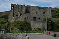 Carlingford Castle.jpg 640 × 426; 148 KB
-
 Carlingford marina - geograph.org.uk - 164953.jpg 640 × 426; 125 KB
-
 Carlingford, Cooley peninsula.jpg 640 × 426; 135 KB
-

-
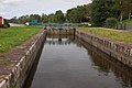 Carnroe lock, River Bann (1) - geograph.org.uk - 234943.jpg 640 × 426; 135 KB
-
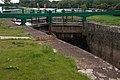 Carnroe lock, River Bann (2) - geograph.org.uk - 235007.jpg 640 × 426; 149 KB
-
 Carrickfergus marina - geograph.org.uk - 206110.jpg 640 × 426; 128 KB
-
 Carrickfergus marina - geograph.org.uk - 206725.jpg 640 × 426; 142 KB
-
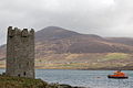 Carrickkildavnet Castle.jpg 640 × 426; 127 KB
-
 Castle Park, Bangor (1) - geograph.org.uk - 189725.jpg 640 × 426; 190 KB
-
 Castle Park, Bangor (2) - geograph.org.uk - 189731.jpg 640 × 426; 165 KB
-
 CastleCourt Belfast.jpg 640 × 404; 81 KB
-

-
 Christie Park, Coleraine - geograph.org.uk - 193868.jpg 640 × 426; 159 KB
-
 Church, Drumbanagher - geograph.org.uk - 175537.jpg 640 × 426; 135 KB
-

-
-
 Clandeboye Avenue at Ballygilbert - geograph.org.uk - 241228.jpg 640 × 426; 171 KB
-
 Clandeboye Avenue, Helen's Bay (1) - geograph.org.uk - 239086.jpg 640 × 426; 174 KB
-
 Clandeboye Avenue, Helen's Bay (2) - geograph.org.uk - 239093.jpg 640 × 426; 159 KB
-
 Clandeboye cemetery , Bangor - geograph.org.uk - 222104.jpg 640 × 426; 172 KB
-
 Clare glen, Tanderagee (1) - geograph.org.uk - 245373.jpg 640 × 426; 182 KB
-
 Clare glen, Tanderagee (2) - geograph.org.uk - 245374.jpg 640 × 426; 203 KB
-
 Clare glen, Tanderagee (3) - geograph.org.uk - 245377.jpg 640 × 426; 184 KB
-
 Classic car, Belfast - geograph.org.uk - 980923.jpg 640 × 359; 73 KB
-

-
 Clattering Ford, Comber - geograph.org.uk - 249927.jpg 640 × 426; 162 KB
-
 Clifton Road, Bangor - geograph.org.uk - 202884.jpg 640 × 426; 160 KB
-
 Clipper Panorama.jpg 640 × 335; 36 KB
-
 Clipper Point.jpg 640 × 405; 74 KB
-
 Cloghan jetty, Belfast Lough - geograph.org.uk - 172672.jpg 640 × 426; 126 KB
-
 Co Antrim war memorial, Knockagh - geograph.org.uk - 176175.jpg 640 × 426; 81 KB
-
 Coastguard vehicle, Belfast - geograph.org.uk - 1546777.jpg 640 × 426; 91 KB
-
 Coastguard vehicle, Howth - geograph.org.uk - 1546794.jpg 632 × 420; 85 KB
-
 Coleraine ring road - geograph.org.uk - 190450.jpg 640 × 426; 126 KB
-
 Colourful MINI, Belfast - geograph.org.uk - 1428481.jpg 640 × 509; 112 KB
-
 Comber bypass (2) - geograph.org.uk - 228242.jpg 640 × 426; 138 KB
-
 Coming into Bangor harbour - geograph.org.uk - 240565.jpg 640 × 426; 130 KB
-
 Commercial Court, Belfast.jpg 640 × 426; 132 KB
-
 Container train, Lisburn - geograph.org.uk - 1442549.jpg 640 × 383; 84 KB
-
 Copeland Island boat - geograph.org.uk - 209130.jpg 640 × 426; 158 KB
-
 Course of old railway at Poland's Bridge - geograph.org.uk - 220502.jpg 640 × 426; 129 KB
-
 Course of old railway near Scarva - geograph.org.uk - 232669.jpg 640 × 426; 149 KB
-
 Cove Bay, Groomsport - geograph.org.uk - 208017.jpg 640 × 426; 125 KB
-
 Craigantlet hill near Belfast (1) - geograph.org.uk - 207275.jpg 640 × 426; 147 KB
-
 Craigantlet hill near Belfast (2) - geograph.org.uk - 207279.jpg 640 × 426; 207 KB
-
 Craigboy Road, Millisle (1) - geograph.org.uk - 214847.jpg 640 × 426; 151 KB
-
 Craigboy Road, Millisle (2) - geograph.org.uk - 233058.jpg 640 × 426; 155 KB
-
 Crawfordsburn, Co Down - geograph.org.uk - 193448.jpg 640 × 426; 150 KB
-
 Cromore level crossing near Portstewart - geograph.org.uk - 219769.jpg 640 × 426; 136 KB
-
 Cromore station near Portstewart - geograph.org.uk - 219758.jpg 640 × 426; 124 KB
-
 Crossing the Suir - geograph.org.uk - 202582.jpg 640 × 426; 141 KB
-
 Crossnamuckley Road, Newtownards - geograph.org.uk - 167774.jpg 640 × 426; 190 KB
-
 Crozier monument, Banbridge (detail) - geograph.org.uk - 232460.jpg 640 × 426; 117 KB
-
 Crozier monument, Banbridge - geograph.org.uk - 232446.jpg 640 × 426; 124 KB
-
 Crozier plaque, Banbridge - geograph.org.uk - 232463.jpg 640 × 426; 118 KB
-
 D-Day mosaic, Bangor harbour - geograph.org.uk - 197829.jpg 640 × 426; 118 KB
-
 D-Day plaque, Bangor harbour - geograph.org.uk - 197832.jpg 640 × 426; 170 KB
-
 Delayed train, Lisburn - geograph.org.uk - 1087236.jpg 640 × 402; 101 KB
-
 Departure from Castletown - geograph.org.uk - 1023654.jpg 640 × 416; 78 KB
-
 Departure from Helen's Bay - geograph.org.uk - 239101.jpg 640 × 426; 151 KB
-
 Departure of the "Jeannie Johnston" - geograph.org.uk - 192523.jpg 640 × 426; 121 KB
-
 Departure of the "Maria Lena" - geograph.org.uk - 189535.jpg 640 × 426; 151 KB
-
 Derailed train, Downhill - geograph.org.uk - 1429625.jpg 640 × 375; 54 KB
-
 Diesel superpower near Ballymena - geograph.org.uk - 1084919.jpg 640 × 371; 94 KB
-
 Disused Lagan Navigation near Moira (1) - geograph.org.uk - 195724.jpg 640 × 426; 157 KB
-
 Disused Lagan Navigation, Goudy Bridge - geograph.org.uk - 195708.jpg 640 × 426; 146 KB
-
 Disused Newry Canal at Poyntzpass - geograph.org.uk - 217271.jpg 640 × 426; 169 KB
-
 Disused Newry Canal at the Madden Bridge - geograph.org.uk - 212884.jpg 640 × 426; 170 KB
-
 Disused Newry canal, Scarva (1) - geograph.org.uk - 175517.jpg 640 × 426; 197 KB
-
 Donaghadee harbour and lighthouse - geograph.org.uk - 184581.jpg 640 × 426; 141 KB
-
 Donaghadee lighthouse at twilight - geograph.org.uk - 221957.jpg 640 × 426; 92 KB
-
 Donaghadee Road roundabout, Bangor - geograph.org.uk - 197776.jpg 640 × 426; 143 KB
-
 Donaghadee Road, Bangor - geograph.org.uk - 218262.jpg 640 × 426; 164 KB
-

-
 Doveholes station - geograph.org.uk - 1681204.jpg 640 × 375; 91 KB
-
 Dover-Eastern-Docks-1987-by-Aubrey-Dale.jpg 640 × 376; 83 KB


_-_geograph.org.uk_-_220953.jpg)
_-_geograph.org.uk_-_220961.jpg)


_-_geograph.org.uk_-_415919.jpg)

_-_geograph.org.uk_-_193937.jpg)
_-_geograph.org.uk_-_193944.jpg)


_vans,_Belfast_-_geograph.org.uk_-_1236572.jpg)
_-_geograph.org.uk_-_1312851.jpg)

_-_geograph.org.uk_-_1254633.jpg)
_-_geograph.org.uk_-_1254684.jpg)
_-_geograph.org.uk_-_1260132.jpg)
_-_geograph.org.uk_-_1266418.jpg)
_-_geograph.org.uk_-_1283894.jpg)
_-_geograph.org.uk_-_1296835.jpg)
_-_geograph.org.uk_-_1323594.jpg)
_-_geograph.org.uk_-_1343540.jpg)

.jpg)
.jpg)
_-_geograph.org.uk_-_1323468.jpg)
_-_geograph.org.uk_-_1323485.jpg)


_-_geograph.org.uk_-_238319.jpg)


_-_geograph.org.uk_-_1419753.jpg)
_-_geograph.org.uk_-_203688.jpg)
_-_geograph.org.uk_-_203694.jpg)
_-_geograph.org.uk_-_203701.jpg)


_-_geograph.org.uk_-_173219.jpg)


_-_geograph.org.uk_-_232216.jpg)
_-_geograph.org.uk_-_232228.jpg)

_-_geograph.org.uk_-_202871.jpg)
_-_geograph.org.uk_-_189749.jpg)
_-_geograph.org.uk_-_189753.jpg)

_-_geograph.org.uk_-_191411.jpg)
_-_geograph.org.uk_-_191414.jpg)
_-_geograph.org.uk_-_191419.jpg)
_-_geograph.org.uk_-_214896.jpg)


_-_geograph.org.uk_-_213332.jpg)
_-_geograph.org.uk_-_213340.jpg)


_-_geograph.org.uk_-_232259.jpg)
_-_geograph.org.uk_-_224577.jpg)
_-_geograph.org.uk_-_234439.jpg)


_-_geograph.org.uk_-_232244.jpg)


_-_geograph.org.uk_-_189762.jpg)
_-_geograph.org.uk_-_207287.jpg)

_-_geograph.org.uk_-_1109624.jpg)


_-_geograph.org.uk_-_1015480.jpg)


_-_geograph.org.uk_-_234943.jpg)
_-_geograph.org.uk_-_235007.jpg)


_-_geograph.org.uk_-_189725.jpg)
_-_geograph.org.uk_-_189731.jpg)


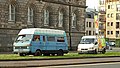
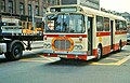
_bus_2055_(LOI_2055),_1976_Bristol_RELL6G_Alexander_(Belfast),_Citylink_livery,_Belfast,_13_August_1976_crop.jpg)
_bus_2055_(LOI_2055),_1976_Bristol_RELL6G_Alexander_(Belfast),_Citylink_livery,_Belfast,_13_August_1976.jpg)

_-_geograph.org.uk_-_239086.jpg)
_-_geograph.org.uk_-_239093.jpg)

_-_geograph.org.uk_-_245373.jpg)
_-_geograph.org.uk_-_245374.jpg)
_-_geograph.org.uk_-_245377.jpg)


_-_geograph.org.uk_-_228242.jpg)


_-_geograph.org.uk_-_207275.jpg)
_-_geograph.org.uk_-_207279.jpg)
_-_geograph.org.uk_-_214847.jpg)
_-_geograph.org.uk_-_233058.jpg)


_-_geograph.org.uk_-_232460.jpg)


_-_geograph.org.uk_-_195724.jpg)


_-_geograph.org.uk_-_175517.jpg)


