
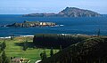
Category:Philip Island, Norfolk Island
uninhabited island in the group of islands comprising the Australian external territory of Norfolk Island in the South Pacific Ocean between Australia and New Zealand   | |||||
| Upload media | |||||
| Instance of | |||||
|---|---|---|---|---|---|
| Named after | |||||
| Location | Norfolk Island, AUS | ||||
| Located in or next to body of water | |||||
| Width |
| ||||
| Length |
| ||||
| Population |
| ||||
| Area |
| ||||
| Different from | |||||
 | |||||
Media in category "Philip Island, Norfolk Island"
The following 9 files are in this category, out of 9 total.
-
 Admiralty Chart No 1110 Norfolk and Philip Islands, Published 1856, Revised 1924.jpg 8,106 × 11,071; 26.08 MB
-
 Admiralty Chart No 1110 Pacific Ocean. Norfolk and Philip Islands, Published 1856.jpg 5,934 × 8,016; 10.4 MB
-
 Clianthus carneus.jpg 1,009 × 1,600; 184 KB
-
 Nepean Island (closer) and Philip Island from Norfolk Island.jpg 400 × 300; 89 KB
-
 Nepean Island from Norfolk Island.jpg 600 × 450; 130 KB
-
 Norfolk Island Philip Island.jpg 1,000 × 591; 275 KB
-
 Norfolk Island Philip Island2.jpg 519 × 651; 206 KB
-
 Norfolk Island Philip Island3.jpg 900 × 483; 210 KB
-


_and_Philip_Island_from_Norfolk_Island.jpg)


